 |
| Top of the mesa trail sign |
I hiked the
Hidden Mesa Open Space Trail along the mesa top 3 times in the past 2 weeks because it is so QUIET. The 2 mile loop trail, just a third of a mile from the parking lot, is an easy, mostly flat hike with views in all 4 directions. My wife joined me for each of these hikes. A map is available at the link also.
 |
| Looking North East |
The peacefulness is just plain inspiring. Bird song was the second loudest noise I heard. Prairie Dog warnings were the loudest noise by far. Even the occasional whoosh of an airplane above was washed away by the wind and that wind was heard through the trees.
I last wrote about the
Hidden Mesa Trail here, when I walked a portion of the lower trail off CO 83 at Franktown. I still have to walk the trail from there up to the mesa top and will write about that when it happens.
 |
| Looking East |
 |
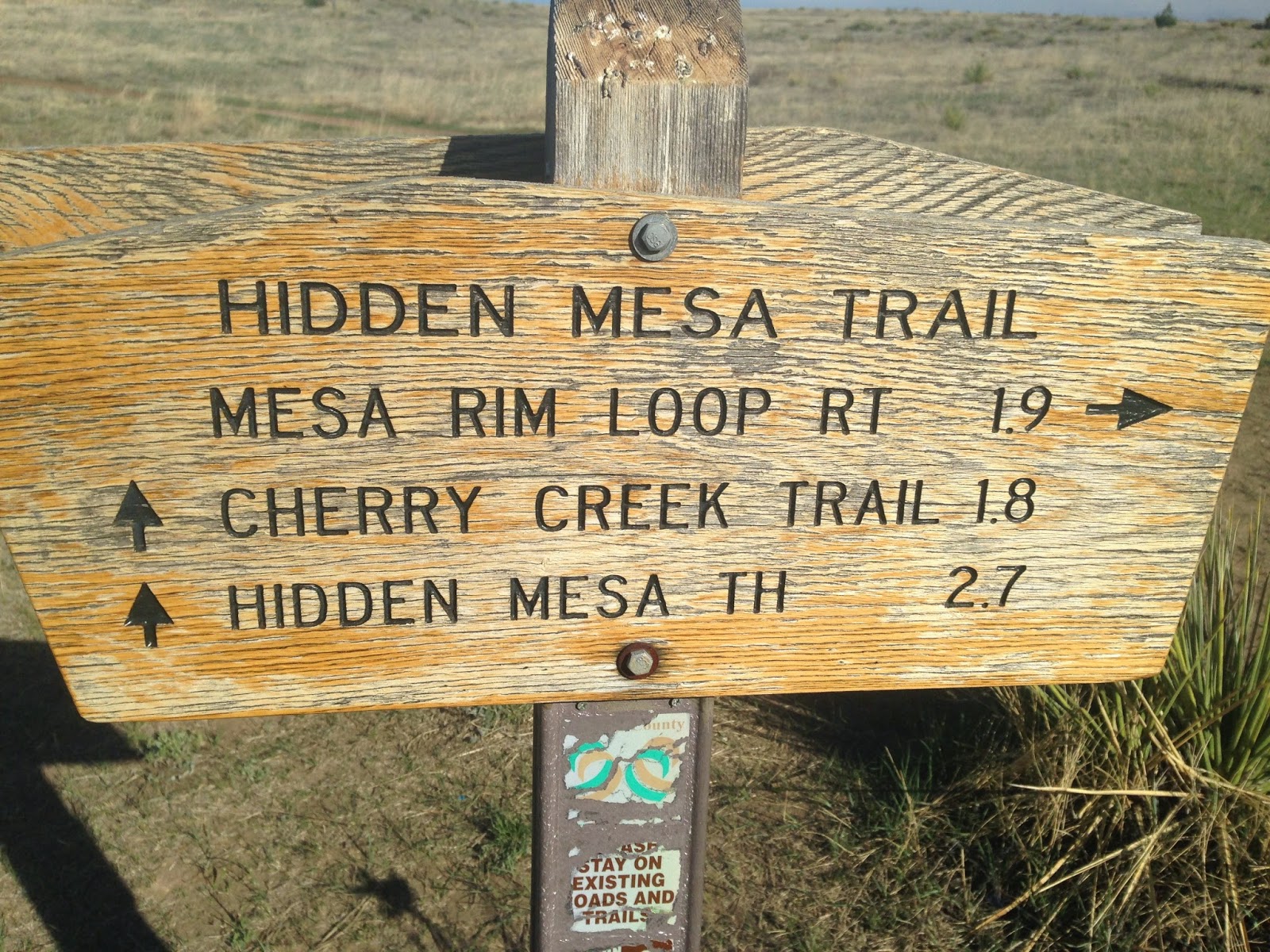
| The trail is well marked |
Most of the walk is in the sandy top soil of the mesa. This sand is from the worn down crust of the top layer of Rhyolite, and is filled with quartz and black, brown and red river stones that came with the Rhyolite. You can read about how this form of
Rhyolite came to be here.
 |
| Rhyolite in its interesting hoodoos |
As you travel counter-clockwise from the parking lot junction, you travel mostly on rock with short sandy areas in between. Conifer trees sprout from the stone along the path and provide moments of shade and add sound to the wind whistling through them. Oak scrub grows mostly from the soil and away from the cliff edge. You can see highway 86 below you beyond the tumble of rocks and occasionally hear traffic on it. The trail continues around the edge, then works back northerly onto the mesa center before running to the edge twice more.
 |
| Looking Southeast |
Now on the eastern side of the mesa, the views are of Cherry Creek below, the farms and Franktown. Below is the 124 acre test farm, greenhouse and orchard next to the old family house of the original farm and acreage that Douglas County Open Space purchased as part of Hidden Mesa. The picnic area and parking lot are next to that, with the farm lane winding down to cross Cherry Creek and then picking up the Cherry Creek Trail going north and south. A couple benches up here provide views to the east and provide a break in your day.
 |
| Early spring flowers |
A lot of old trash has washed on down the mesa to the right. Behind the oak scrub there is an old refrigerator, a furnace and half an acre of rusting tin cans. My hope is someday they will remove this trash, recycle what they can and bury the rest. The mesa top deserves that.
 |
| Natural surface trail |
 |
| Showing the route and distance to the Trailhead on CO 83 below |
The trail continues on, turning to the left before its junction with the trail to the farmland below. Prairie dogs squeak here, warning others of the danger. It is fun to watch them run from hole to hole, pop up and down and suddenly go quiet when you get too close. A couple holes are right next to the trail and I expect these prairie dogs are very busy sounding the alarm on weekends.
 |
| It is nice to have signs as nice as this one |
 |
| Bench for relaxing |
A mountain biker whizzes by after announcing his presence, then thanks us for stepping off the trail to let him pass. Nice trail etiquette! This trail is quite popular with the mountain bikers. It has some technical challenges mostly along the rock edges, and gives a good climb up the ridge, but it is not too technical for novice riders. Plus it is close to Castle Rock, Franktown and Parker.
 |
| Rhyolite near the edge |
Mostly in the open now, we look to the north and follow the view of the mountains of the front range until they fade in the distance. We climb a hill and drop down a little to the parking lot trail by the bench. Returning to the car is fairly quick, with just a short drop and a few turns along an old farm road.
 |
| More spring flowers |
The gate here closes automatically at dark. We sit and talk a while listening to the wind, and finally leave as another mountain biker pulls in. It has been a peaceful afternoon.
 |
| Parking lot for Hidden Mesa |
Getting here is easy. Take I-25 south of Denver to exit 184 at Founders Parkway, then follow to the left through the stores 2 miles to the Terrain Subdivision on the east side of the road. Turn left into the second entrance which is Rising Sun Drive, follow left through a roundabout to Autumn Sage Street, then turn left onto Castle Oaks Drive. This takes you downhill by the remains of an old farm, and crosses a stream. Then take the second gravel road right onto Pleasant View. Follow this to the top where the parking area is, park and hike. There is a Port-a-let at the end of the parking lot.


