 |
| The light gray in the photo ahead is the Great Sand Dunes National Park |
6 AM came early. Get up, grab the phone to shut off the alarm. Get right into the shower, get out and get dressed. Eat breakfast. Shoulder the backpack and lock the door behind me. Drive right out to the Interstate and head south for 3 hours and 15 minutes. I know where I am headed today, to the Great Sand Dunes National Park in the San Louis Valley of Colorado.
I chose this location, this park because of the 30 square miles of sand dune wilderness I plan to get lost in today. That wilderness hides behind 70+ foot tall mountains of sand, beyond
Medano Creek, beyond where most visitors meet the park.
 |
| A rare selfie |
At the visitor center I give the ranger my information and answer her questions to receive my back country permit, one of only 20 they will give out today. I attach it to my pack, then park my car where they tell me. I eat most of my lunch and hydrate before putting on the backpack, cinching the straps tight and heading down the trail to cross Medano Creek. I shot a selfie (which I rarely do) as proof that I am here, actually backpacking the Great Sand Dunes! Elevation here is 8200 feet.
Reaching the creek, I pick my way across, not concerned about my feet getting wet. I do release my waist belt as a precaution I learned years ago when crossing water and use my walking stick to test the few inches of depth. I experience the
pulsing waves, an action that only happens in a few places in the world including here. That's really cool.
I cross the creek and remove my pack to filter water for my additional 2 quarts of water I will drink later tonight and tomorrow on my hike back out.
Once watered, I hoist the pack and start heading uphill. It is cool here with a light breeze at 10:30. My feet sink 5-6 inches into the sand and slide backward or downhill another 8 inches laterally for each step up that I take. Sometimes I slide further downhill. This "hill" is steep, and it is getting steeper as I climb higher. After some difficulty, I reach the top and here I stand on top of the sand.
The view stretches out before me, with High Dune (with a line of people waiting at 700 feet high) to my left, and Star Dune (highest at 755 feet) along the left side of that. Dunes rise and fall, mostly in ridges running north-south in front of me to end in the mountains of stone 6 miles in my front, and reach west to where they end in the wetlands and lakes. To my right, the dunes pile higher, up to my height as they lean into the Sangre DeCristo Mountains to the east. This is what 30 square miles of wilderness looks like. Big. Empty. And beautiful.
 |
| High Dune |
 |
| Backpacking Through Grasses |
 |
| Differing Textures of Sands |
The sands change colors and textures, plants like Scurfpea, Small-Flowered Sand Verbena and Indian Ricegrass fill the valleys, small shrubs line some areas, deep holes drop with steep sides into darkness. These dunes do move over time, which is interesting to consider this hill may not be "here" on the next trip. I now know how difficult it is to climb the steepness, sometimes on all fours. At first I moved west to reach the High Dune, but later changed my plan and began working north with my sight on a tall dune near the mountains. As I begin moving north, I follow the ridge to where I can start climbing to the the next ridge, slide down a short drop and cross to the west, then climb to another ridge top, then follow across the sand face to drop behind the next sand row, and drop to the shelf against that wall.
The sand wall is now 50 feet above my left as I step deeply in the soft, hot sand, heading for the shelf far below where I plan to eat the rest of my lunch and rest a bit. This has easily taken a couple hours. Here is where I first realize the sand is both deep and almost solid, the crust is beginning to hold me here, like it did on top of the sand mountain. Moving on down near the grasses, I find harder sand compacted and can momentarily walk upright. After a while I reach a level area and stop for a break, removing my pack and placing my Z-Lite pad on the hot sand to sit on.
 |
| My Path Down |
 |
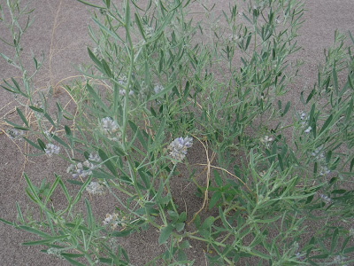
| Some Of The Plants Inside The Dunes |
 |
| Surviving Plant At The Lunch Site |
A strange-looking plant sits beside me with many stringers on top that look like roots around an arm-thick trunk. I drink plenty of water and eat my raisins. Clouds appear fine above me, and after a few minutes begin to thicken and turn dark. Now I hear thunder, but it sounds far away. I sat up listening and watching the sky darken more. After 15 minutes of conditions worsening, I took out my tent and set it up, using grocery bags as stakes, filled with sand. I got 4 of the 5 bags finished when the rain hit hard, and dove into the tent to stay dry. The wind whipped the REI Quarter Dome, with my pack and I inside, sometimes pounding my body with the main tent pole, sometimes vibrating the material loudly, always with the rain pelting the tent hard, with big drops and hard hail. For 90 minutes I was beaten fiercely until the storm settled down. I climbed out, fixed the 5th bag of sand to the back of the tent, re-positioned the tent more in line with the wind and dove back in to avoid the second pouring which lasted until 4PM. I must have napped, because it didn't seem that long stuck inside the tent.
 |
| The sky goes from kind of clear to... |
 |
| ...Threatening in a few minutes, along with the sound of thunder... |
 |
| The second storm cometh... |
 |
| Grocery Bags Filled With Sand To Hold Down The Tent In The Dunes |
I had been warned to leave the sand dune field during a thunder storm, but that had not been possible due to how far I was into the dunes. I was situated low on a shelf with a 70-foot high wall to my west so I believe I was in little lightning danger. Regardless, it was a dangerous situation I was in and I suggest you plan better than I did for your safety.
After the second rain and thunder stopped, I climbed out and looked toward my destination in the north, figuring I could make it there and setup the tent again for the night. So into my outside pack pocket the dripping tent went, and off I went under the cloudy sky. I had to climb down from the step where I was and cross the bottom land to where I could begin climbing up again, following a rising ridge to reach the mountain I wanted to camp on. I followed around to the right, then up to the left, slipping back 1 step for each 2 steps I took up. The sand was only wet at the top, about a quarter inch down it was as dry as if it never rained today. I passed 2 outcrops of clay sediment, and felt it was strange to think there is something other than sand underfoot. The camera had been refusing to focus today as there is nothing here to focus on, so my apologies for the photos. I finally reached the saddle below the sand peak and found it was hard pan sand, before climbing up the hill. The view from here was good to the south, I was protected from the west winds by the sand hill 40 feet above me, and was open to the southwest with a fine view across the dunes to where I would climb back out tomorrow,
 |
| My Path |
 |
| The Folds Of The Dune Behind |
 |
| That Green Spot, Right Of Center Was My Lunch Site |
 |
| The High Dune I Was Heading Toward For Camp |
 |
| Tent Setup For The Night |
I setup my tent, filling the bags with sand again, this time not having to rush to beat a storm. I took a break, climbing to the wall above me where I tried to fly a kite in the breeze, but couldn't get enough of a run across the ridge top to launch the kite. I climbed most of the way to the top, but slipped back down when I turned to enjoy the view. I did see endless dunes receding to the west, all the way to the wetlands and lakes which now shimmered silver in the sun.
 |
| The 70 Foot High Dune That Protected Me Earlier |
 |
| Dunes And More Dunes |
 |
| Clay Under The Dunes |
 |
| View Southwest |
 |
| View South |
 |
| Sunset |
I returned to my tent, cooked dinner, ate and cleaned up. I cooked organic mac & cheese, half of a box package with chicken, in a freezer bag. I boiled water
using my propane backpack stove, added the noodles and simmered them 5-6 minutes until al-dente and drained the liquid. Then I added the noodles back into the baggie, along with a teaspoon of coconut oil, the half package of cheese and a small, drained can of chicken. Mushing this all together in my warmer bag, it tasted good. It was way too much for me, sized at a serving for two, but I ate it all and slept well.
During my climb above the tent, two people had setup their tent about 1-2 miles to my east at the top of a ridge. They were so far away, I could only tell there were 2 people and a dome tent.
As it darkened, the sky remained cloudy. I sat outside in the mosquitoes for an hour or two, wearing my head net, but the sky didn't clear so I turned in for the night.
 |
| View To The West, My Tent Down Below, Lower Left |
 |
| One Of The Many Plants In The Dunes |
 |
| The Circles Are Made By The Plant Blowing In The Wind |
 |
| Morning View Of My Campsite, Leaving No Trace... |
At one point in the night I awoke, it was so bright I thought I had slept all night to morning. I went ahead and got dressed, getting out of the tent to discover a quarter moon was lighting the sky like sunrise, and the stars were out! As I stood, looking into the vastness of the Milky Way, a shooting star shot through the center of my vision. I stood there a few minutes enjoying the awesome beauty of the night sky, which I miss so much! After a few minutes, I could make out a few stars and constellations, and the planets Saturn and Mars to the south. This was so incredible, a clear sky with absolutely no light pollution! I stood about 45 minutes just looking up, the silent folds of the dunes marching away from me, the light breeze just keeping the bugs at bay.
That motor that woke me up was a red and white airplane, flying low over the dunes. I took a photo because it was the only motor sound I had heard since 10:30 yesterday morning. The dunes are like that. The sound is swallowed whole; you don't hear cars or trucks whizzing by, air conditioners roaring on or trains clickety-clacking. Only one airplane. I went ahead and packed up the tent, brushed my teeth and planned my escape.
The ground was covered with tracks, most small, some that looked like bicycle tires, others where you could see the tiny feet. They had been busy all night.
I followed my own footsteps down the bench and crossed the lower open area. I avoided the campsite I could see, as bodies were moving around it now. I followed the side hill and climbed 2 ridges before stopping for a break. As I dumped the sand from my shoes, 2 backpacking women (from the campsite I could see) passed me, saying good morning. I asked how going barefoot was (one was barefoot, the other wearing socks) and they both said it was the way to go. It was still early and the sand was still cool, not the 150 degrees it was before yesterday's rain. These women must be awesome athletes to backpack here in the sand. We parted, they going east, me going southeast, they going down, me going up. The next time I paused for breath, they were far below me. A few minutes later I saw what I think were 3 men, about 3-4 miles away. That was it for being social in the wilderness.
 |
| Dune Cornice Wall, Sand Blown Back Against The Prevailing Winds |
 |
| Back Toward My Campsite |
 |
| Higher Up |
 |
| That Speck Is The Two Women I Met Earlier |
 |
| My Hill To Climb |
I climbed and climbed, finding more compacted sand today along my route than I did yesterday. I watched the sand "cornices" where the sand is blown back over the top by the winds from the east, against the prevailing winds from the west. It was interesting how the sand was scalloped here. I daydreamed a few minutes, waving in my imagination to Stilgar as I slip-stepped to keep the sand worms from hearing my rhythmic crossing as I neared the Sietch...
 |
| Lightning Victim? |
 |
| The Ridge Crest |
 |
| My Last Big Push |
 |
| Scallops along the ridge top |
At one point, I saw a circle of what looked like broken asphalt, with small stones inside the circle. I didn't dig into it because if it was something that was struck by lightening, it deserved to be left alone.
Eventually, I went down on all fours as I reached the top of the hill to climb over the cornice, rising up to see the park campsite, access road and the visitor center far below. It was now all downhill from here. That downhill walk took more than an hour and covered a couple miles of navigating back and forth. Finally, I unbuckled my waist strap again as I crossed through Medano Creek. I chuckled when I saw the 2 women I had met earlier, coming down the stream. I headed up the trail, stopping for a crinkled Great Sand Dune Wilderness Sign photo, before heading on to my parked car. "Where man himself is only a visitor."
 |
| Standing On Top Looking South |
 |
| Where Man Himself Is Only A Visitor |
I stopped at the visitor center to wash my hands and fill a water bottle before leaving. I had a 25 mile drive before I could text my wife that I was OK, and get gas, so...
...so I asked myself what I felt, and I felt fine, refreshed, clear, focused, and happy. I felt rested from the solitude and refreshed from the open sand, air and sky. What a great trip this was!
Over the miles home, I must have had too much time to think. The next time I will bring my snowshoes and poles (what better way to walk across the sand?) and enter from the west side of the park, where the sand hills are lower, and cross into the dune area I didn't get to this trip. And maybe carry more water, I finished with just 2 cups left this time.
Other areas here include Montville Nature Trail, Mosca Pass Trail and the Sand Ramp Trail which leads to backcountry sites. Alpine Trails include Modano Lake, Mount Herard, Music Pass and Sand Creek Lakes. High-Clearance 4-Wheel Drive trails also include campsites and all sites have incredible views. You could also spend a few days in the dunefield provided you left to retrieve water daily. Nearby sites include Zapata Falls and Buffalo Tours, San Louis State Park, Fort Garland, National Wildlife Refuges, Alamosa, San Louis, and Blanca Peak.
To get here, follow I-25 south of Castle Rock 129 miles to exit 52 at Walsenberg. Follow Walsen Avenue south through town to turn right (west) onto US 160. Follow US 160 over the pass, through Fort Garland (get gas here) and Blanca, and following the signs to the Great Sand Dunes National Park, turn right (north) onto CO 150 f
or about 20 miles. This road leads you past Blanca Peak, a popular 14-er. You will first see the dunes from this road, as in the first photo of this post. Pay the admission fee of $15 at the park entrance gate. Back country passes are free and are available first come, first serve at the welcome center on your left. Enjoy your drive as this takes about 3 hours and 15 minutes from Castle Rock without stops. Cellular service ends around Fort Garland.


No comments:
Post a Comment