Friday, April 29, 2016

Road Trip - Sand Creek Massacre National Historic Site

Sand Creek Massacre National Historic Site.
My drive east across the Colorado prairie was detoured by a late spring snow, so I drove south first to Pueblo, then went out east across the Big Empty. There was no snow along this route. There also wasn't much else to look at, except for a few small communities marked by grain elevators. This was a very long Road Trip across almost featureless plains.
I did stop along the road to shoot a few photos and I have included those below.
The Sand Creek Massacre National Historic Site is located along Sand Creek, which was also called Big Sandy and during the mid-1800's was part of an Indian trail into the region.
The ranger on duty told me "this site commemorates a national tragedy". Please read about the massacre HERE. There are many sites online, books, films and TV stories about the event. Living in Colorado, you become aware of the Sand Creek Massacre very quickly. Please click PLAY on the short video below.


The flag you see in the at the start of the video, is a 33 star flag, similar to the one Black Kettle flew from his tee pee with a flag of truce that fateful morning of November, 28th 1864. What I found there and tried to show in my short video, was peace. And quiet. Birds were the only sound I heard at the site other than wind.  The few others who visited while I was there were thoughtful, respectful and quiet too. I feel it is important to remember these terrible events, the times that are not shiny and clean. Maybe by remembering them we can choose to not repeat them.
From my road trip (almost to Kansas) here are some photos from along the route.

Rusted Railroad Fuel Container along Highway 96 East

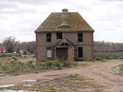
Once-nice abandoned home along Highway 96

One of many cool old buildings in Ordway, CO

Cannot refuse an old street sign in Ordway, CO

Star of Sugar City, CO
I continued driving south along back roads to La Junta, CO, then followed the Santa Fe Trail route to Trinidad, CO where I spent the night.
So far my Road Trip began in Castle Rock, followed I-25 south through Colorado Springs (where I last saw snow) to Pueblo. There I turned east onto highway 50, then left onto highway 96 east. At Eads, you pick up US 287 for a couple miles, then turn left onto 96 east again. Follow this to Chivington and turn left onto county road (dirt) 54. Follow this road north until you hit a T stop, turn right, then left into the National Historic site.
When leaving, return to 96 and follow it west through Eads to Colorado Highway 31, then left/south to Cheraw. Pickup highway 109 at Cheraw and follow south to La Junta. Go west on highway 50 and then go south on US Highway 350, and follow the Santa Fe Trail to Trinidad. A long, full day Road Trip! More Road Trip to come!


Friday, April 22, 2016

Road Trip - Highway of Legends

Highway of Legends!
Colorado's Scenic Byways always take you somewhere really cool and unusual! This route, the Highway of Legends, loops around the two Spanish Peaks which tower over the region. I drove from Trinidad in south Colorado clockwise around these mountains to Walsenburg, following Colorado Highway 12 and US 160.  West Spanish peak has an elevation of 13,626 feet with the East Spanish Peak topping out at 12,683 feet.  The 17, 855 acre Spanish Peaks Wilderness Area includes both summits and offers great hiking and backpacking opportunities. Click HERE for more of the legends and stories about the area. Geologic information about the spectacular dikes formed in the region are available HERE.
The first part of the loop, starting outside of Trinidad was very much like driving through Appalachia with visible seams of coal in the roadside cuts and oppressive poverty with abandoned buildings and junked cars providing homes for weeds in the unkempt yards. There was much poverty here, with much money in the land up and away from the road, funding weekend farms and get away cabins just up the mountain behind them.

Welcome to Cokedale
After passing the entrances for the Trinidad Lake State Park, you arrive at Cokedale, surrounded with man-made mountains of slag and the old coke oven structures. Over 140 people now live here full time in the towns historic mining houses, the community was placed on the National Historic Register in 1984. The American Smelting and Refining Company had sold the land and homes to the miners at reduced prices.
A quick drive takes you through Cokedale's community neighborhoods, by the old school house, and around the old miner's office and the (privately owned) Gottlieb Mercantile Company.  This was once a model mining community with a population of 1500 in 1909. Founded in 1906, it operated over 40 years to when the company sold out in 1947 due to a decrease in the sale of coal. During those years the coke ovens ran 24 hours daily. 2 mines provided coal from above the town with another providing coal from a few miles away. Coke was made by first washing the mined coal, then cooking the coal to remove impurities and moisture, so it will burn hotter in the iron smelters to make steel. Slag is the byproduct of coke, and is mostly made up of slate and sulfur.  There used to be a trolley into Trinidad, serving the miners, costing a quarter for the 1.5 hour ride.

Coal Washery remains

The rows of Coke Ovens

Gottlieb Mercantile Company

Mounds of slag
The road out of town runs along the Purgatoire River, twisting and turning along with the old railroad cut on the southern shore. I pass a modern and working coal mine on the left. Finally I get to Stonewall, where I turn north along the loop around the mountains. Stonewall is named for the stone wall that abuts it, which was created by an uplifted wall of lava which had formed in cracks in the ground. This town looks like one of those 1960's camping vacation towns, with cabins and hotels tucked into the heavily wooded forest. The actual stone wall the town is named for splits so the road can pass through it. I paused to eat lunch in the car (it was cold outside) in a lodge parking lot. Across highway 12 was a gate marking the entrance to where WWII German Officer Prisoners of War were kept. The town smelled of pine trees and the whole community appeared to be waiting to open for the season.

The stone wall at Stonewall

Through these gates were kept WWII Prisoners
Driving onward, the road past the stone wall makes a right turn and immediately begins climbing up to Cucharas Pass at 9938 feet elevation (the sign there reads 9995 feet elevation) and the intersection with Forest Service Road NF 46 or FR 415 or Road 364, all numbers are listed on my maps. There are no houses here, just trees, rock walls and snow. And views!
Just a few miles on down the road is the Town of Cuchara in three separate areas.  You can check out the local places like Dakota Dukes or the Cuchara Country Store while in the area.
Following Highway 12 on down the mountain brings you past several of the stone dikes, one with Gollum stuck in it : )

One of the many mountain lakes along Highway 12

Lots of Aspen, pines and views

That's Gollum in the dike!!!
My drive encountered sunny, cloudy, rainy and snowy conditions but with the roads being cleared, was an easy drive in a 2 wheel drive car.
Near highway 160 you find La Veta, another fine mountain community nestled along the base of the Spanish Peaks. Taking a right along US 160 takes you to Walsenburg and the end of the Highway of Legends.

The Spanish Peaks under snow


Friday, April 15, 2016

Coming Up - Free National Park Entry Dates


Don't say I didn't warn you!
Beginning tomorrow, April 16 through 24 is National Park Week!  Enter a National Park for free all week!  Check out the link above for more parks.
In Colorado there are: Rocky Mountain National Park, Mesa Verde National Park, Great Sand Dunes National Park and Preserve, and Black Canyon of the Gunnison National Park.
Also there are 8 National Monuments including: Browns Canyon National Monument, Colorado National Monument, Canyons of the Ancients National Monument, Chimney Rock National Monument, Florissant Fossil Beds National Monument, Dinosaur National Monument, Hovenweep National Monument, and Yucca House National Monument.
And there are 3 National Heritage Areas: South Park National Heritage Areas, Sangre De Christo National Heritage Areas, Cache la Poudre River National Heritage Areas.  You can read more about these HERE.
Visit a park near you!!!

Friday, April 8, 2016

Backpacking the West Spanish Peak Trail

Spanish Peaks, Colorado
One of the ultralight trips I am planning to do this summer is backpacking in the historic Spanish Peaks Wilderness Area of southern Colorado. I have located two hiking trails, the Apishapa Trail and the Cordova Pass Trailhead that combine to climb to the 13,626 foot West Spanish Peak summit starting from a scenic, unpaved route. Just below the talus slopes on the west side of the peak there is a saddle around 12,000 feet in elevation that by map looks appropriate for an overnight camping spot. The area is located within 19,226 acres of wilderness and the combination of 2 trails provides an almost full day trip, if I first backpack up the west peak, then traverse to the east peak, shoot some photos and retrace my path back to the saddle below the west peak to camp for the night. I need to better evaluate the off-trail route to the East Spanish peak and back before I go, and purchase some micro spike traction devices for potential ice along the trail. From looking at the maps on CalTopo mixed with Google Earth, it looks challenging, doable and fun!
To make a better trip, I could then travel by car the next day west over the divide to the Great Sand Dunes National Park, and backpack and camp on the sand dune that night. I have read that the clear Colorado sky there gives great views of stars and constellations during the night. Some people even report UFO sightings in the Crestone area to the north of the park, which could be cool or terrible, an adventure in every way.
Either way, it would be an awesome two night, two location backpacking trip to two of Colorado's signature natural areas along with a scenic drive tunneled through a volcanic dike.
I will publish more backpacking information as I get closer to trip time, and a trip report when I return.

Friday, April 1, 2016

A Better Funnel?


The old style plastic funnel

I have long used a small plastic funnel to capture a trickle of water for treating in the outdoors with my water purifier when backpacking. Many of the outside above ground water sources are small trickles, where water follows its path of least resistance while being drawn downhill by gravity. Perhaps you have some experience with this on your backpacking trips and like me, seek a better way.

The new style of silicon collapsible funnel
While shopping for kitchen supplies I came across a set of various sized and inexpensive collapsible funnels, made of silicone. While not new to the world, they were new to me and inspired an idea for their use beyond the kitchen. I believe they can be easily held, bent and folded for improved fit around natures endless variety of contours of rock and earth in a way to better capture those elusive trickles of necessary water. I like the way they fold or collapse to better fit inside my backpack and the fact they won't melt by heat or be bent useless under the weight of backpack items. They also come in bright and fluorescent colors so they will not easily be left behind.


I will use one of these lightweight and flexible funnels this summer during my backpacking trips and tell you how well, or even if it works, as an improved capture method for drinking water for purification. If any of you already have real world outdoor experience capturing drinking water with a silicon collapsible funnel like this, please comment to let me know how well it works for you.