Friday, September 25, 2015

Road Trip - Los Alamos, NM

Vintage photo of the Los Alamos Main Gate
Los Alamos is the town our government built in New Mexico to create the first Atomic Bomb during World War 2. Originally the Los Alamos Ranch School for boys founded by Ashley Pond II, the land was bought in 1942, the people relocated and the scientists moved in.
Secrecy was paramount, with all mail sent through a Post Office box number in Santa Fe.  Even drivers licenses were filled in with the Santa Fe address and a number for the name. The entrance was gated and guarded at all times.
Today, Los Alamos is still the home to the Los Alamos National Laboratory which sits on the mesa to the south of town. Busy and secretive, it is still the government at work on things they don't want us to know about.
The town itself is small, with no big-box stores, probably due to the land area being already filled in. We passed the High School and Library, the Aquatic Center and the Senior Center and lots of homes. A small town, it is full of modern history and stories of technical conquest.
We toured the Fuller Lodge and the Los Alamos Museum next door and the ancient Pueblo on the lawn beside it, behind bath house row. A little known detail that I liked about the Ranch School was they required each boy to become a First Class Boy Scout to graduate.
We also saw the Bradbury Science Museum which has full sized models of the Atomic bombs dropped on Hiroshima and Nagasaki, and watched a film about it.
While the Atomic bomb was developed here, it was detonated at the Trinity site 220 miles south near Socorro, NM.  That is another site for me to see.
Right across from the Post Office on Central Avenue is a strip center with the finest fresh bagel and sandwich shop I have ever enjoyed.  Save room for a meal at my friend Ruby K's Bagel Cafe.
Los Alamos is about 45 miles from Santa Fe.  Go north on US 285 and 84 NM 502, go left (west) and follow the signs to town.


Friday, September 18, 2015

Road Trip - Tsankawi


Center of Tsankawi
Tsankawi lies about 12 miles north of Bandelier National Monument on NM 4, and is located at a gravel parking area along the highway. It is still a part of Bandelier National Monument. Hike down the trail and pay an entrance fee at the shelter, or post your Bandelier pass on your dashboard. The trail runs about 1.5 miles and should take about 2 hours. Carry drinking water.

Top of the second ladder with a view north and back to the parking lot
More ruins
Tsankawi is the remains of a mesa top pueblo, home to the Ancestral Tewa Pueblo people. This Pueblo is not reconstructed, and will not be, at the request of the San Ildefonso Pueblo people, descendents of the Tsankawi people.
While that may not sound appealing, it really is because when you arrive there you actually have to look closely at the area and think like an archaeologist. It is really cool!
The trail climbs to a spot with a ladder, where you climb onto the "lower Cliff" on top of a stone platform. From there continue along the path to the right where you come to a trail junction, go left.  Climbing higher you soon notice troughs or steps worn from the rock, some perfect for stepping up to the next ledge. These trails were carved by the feet of Ancestral Pueblo people walking up and down the mountain to tend fields and carry food and water to the Pueblo. Soon you reach another ladder to climb to the "high cliff". Once you climb this ladder, you continue walking up the mountain and finally reach the top.
Off to your left in the valley below you can see some ruins. This is the ruins of the Dutchess Castle, built in 1918 to teach pottery skills to the modern Pueblo peoples.

Dutches Castle ruins
Tsankawi ruins, cisterns, kivas and stone walls
Continuing along the trail you will pass through a narrow area, then reach a plateau on top of the mesa.  Before you lies Tsankawi, buried in piles of sand, stones, cactus and shrubs.  The walls have fallen, many that were 2 stories tall, Kivas have filled in and the path climbs through the piles of stone. in some places you can see straight lines of stone walls, in others there are many depressions, some made to retain rain water like a cistern. There were once 275 ground floor rooms here, and a large central plaza where Ancestral Pueblo peoples cooked, worked on pottery, processed food and played games.

Worn pathways on the way down, made by the Ancestral Pueblo people
Petroglyphs along the trail
The trail continues to another ladder that leads down and to the right. Follow this trail past petroglyphs and cavates back to the lower stone platform, down that ladder and back to your car.
We noticed Tsankawi on the way in to Bandelier, but did not stop until the return trip.  It is at the crossroads where you travel to from White Rock to Los Alamos on NM 4.


Friday, September 11, 2015

Road Trip - Bandelier National Monument

Pueblo Tyuonyi ruins, one of several Ancestral Pueblos at Bandelier National Monument
Bandelier National Monument is a 33,727 acre park preserving Ancestral Pueblo sites and keeping the area safe which has hosted human activity for over 10,000 years. The Frijoles canyon area holds the Tyuonyi Pueblo, Long House and talus houses of cliff dwellings. Bandelier holds over 3000 documented Ancestral Pueblo sites with very few restored. The main loop trail is only 1.2 miles long and is partially handicapped accessable.
The Ancestral Pueblo people, once called the Navajo word Anasazi for "Ancient Enemies", came to this land around 10,000 years ago, starting as hunter-gatherers, roaming the mesa tops above the canyons where they eventually grew the 3 main plants of the time: corn, squash and beans, and hunted small animals for meat and hide. 

Swiss Cheese-like holes in the soft volcanic tuft
And carved Cavates in the tuft
The mesa top is called Pajarito (for little bird)  and was formed by two violent volcanic eruptions of the Jemez Mountains 14 miles to the west about one million years ago, now the site of Valles Caldera National Preserve. Each of the two eruptions were 600 times more powerful than the 1980 eruption at Mount St. Helens.

Looking up the canyon walls
Morning light on the cactus
The soft volcanic tuft now looks like Swiss cheese along the Frijoles Creek area.  Trees and shrubs grow well in the canyon alongside the permanent stream and draw wildlife. The reliable water source must have been very important to the Ancestral Pueblo people, providing drinking and cooking water, plus water for plants.

Canyon wall houses
Inside the Cavates with the metates
The 400-room Tyuonyi Pueblo housed about 100 people. There were 3 kivas inside the walls and only one entrance. Ground floor rooms typically stored food and turkeys, with family housing above. Most rooms were either entered via a rooftop ladder, some by a small doorway. Ceilings were wood logs covered with earth and mud, random awnings shaded some homes.

Roof entry
Ladders, ladders everywhere
The south-facing canyon walls, warmer during the winter, held 2 story Pueblos with 2-3 stone built rooms, with one or two rooms carved from the cliff face using stone tools. Cavate ceilings were blackened with soot to harden the stone and make it less crumbly. Horizontal rows of holes show where the roof beams were placed. The walls and floors were mud plastered, requiring constant maintenance.

More Cavates, more ladders
The beginning of the Long House along the cliff, note the holes in the wall for ceiling posts
And steps with helpful modern handrails
The Long House ruins go almost half a mile along the cliff face.  One painted wall was uncovered and is now on display. Petroglyphs are cut above the roofs into the cliff with carvings of turkeys, dogs, lightning and parrots. Yes, parrots were traded here, along with copper bells as part of an extensive trading network from Mexico to the US Central Plains. The petroglyphs seem to have much deeper and specific meanings to the native people who carved them, and may be considered another language. Ideas were traded here too as there are significant construction techniques found in the big kiva that mirror those found at Chaco Canyon and Mesa Verde.

Found hidden behind plaster, this wall shows how it had been painted at one time
The petroglyphs are hard to see, but they are above the holes in the wall
More petroglyphs
And more, here you can see the circles clearly

The parrot petroglyph in the cleft
Alcove house is a steep climb 140 feet above the creek floor on ladders and stone stairs on the north-facing cliff wall. We did not climb there today, but expect it is much like Balcony House at Mesa Verde.
500 people were living here at the peak on the Pajarito Plateau around 1325 CE. Most Pueblos ranged from 150 to 500 rooms, some contained 1000 to 1500 rooms.
It has been 450 years since people lived in the Pueblos at Bandelier, and they had lived there previously for 400 years, growing food, raising children, and living life. Modern Pueblo peoples still visit the site and respect their elders. There is so much more to explore here and I'll be back to spend more time at Bandelier.

Frijoles creek on its way to meet the Rio Grande
View of the cliff face from the creek
Looking back at the cliffs from the visitor center, the large kiva is on the left just past that tree
Bandelier National Monument runs shuttle buses every 30 minutes daily 9am to closing from the park welcome center in White Rock. Parking at the canyon site is extremely limited and the buses make it a much safer trip. If you are camping at Juniper Campground, drive on to the actual park entrance, pay there and setup camp in the campground.  Keep your entrance tab for the bus.  A bus also runs from the campground down to the Frijoles Canyon every 30 minutes.

Parting shots of flowers on the way out

To find Bandelier National Monument, drive north on US 285 & US 84 from Santa Fe, turn left onto NM 502 and follow to NM 4 near White Rock. It is about a 40-45 minute drive from Santa Fe.

Friday, September 4, 2015

Road Trip - Roswell, NM

Alien display inside the Roswell International UFO Museum
There are few places in America emptier than the land southeast along US highway 285 from Santa Fe, New Mexico to Roswell. Heading south through the sagebrush hills there was Clines Corners, only a store at the I-40 crossing; Vaughn, a once small town dwindling away to only a couple occupied buildings; and Ramon, another town living only from the hotels and gas stations supporting a nearby military base.
Once we crossed I-40, the land flattened and rolled easily into the distance. Endless ups and downs as far as you can see. I found it quiet and peaceful, with the views going on forever. My wife mostly slept.
It is a 192 mile, 3 hour drive, one-way. But we felt we couldn't do any better than take a full day to drive to Roswell and back as it is well south of Denver, and not an area we planned to travel again anytime soon. And we wanted to see the one and only Roswell, site of the first documented and much argued about alien encounter.

International UFO Museum and Research Center in Roswell, NM
The Capitan Mountains and Carrizo Peak loomed in the hazy distance to the far right as we drove south. To pass the time we talked about alien encounters and abductions while scanning the sky for anything "unusual".
Roswell seems to be a small, hot and dry town with a Target and a Walmart and a lot of traffic for its size. Actually, over 48,000 people live there. Today the high temperature was 101 degrees, a bit hot. It is home to Eastern New Mexico University and the New Mexico Military Academy, 2 high schools and an airport.

Little Green Men peek from almost every business in town
As we drove through town there was an alien theme everywhere you looked. The McDonald's was shaped like a flying saucer, green triangular alien faces looked out from almost every business sign, short alien-shaped statues adorned many more buildings.

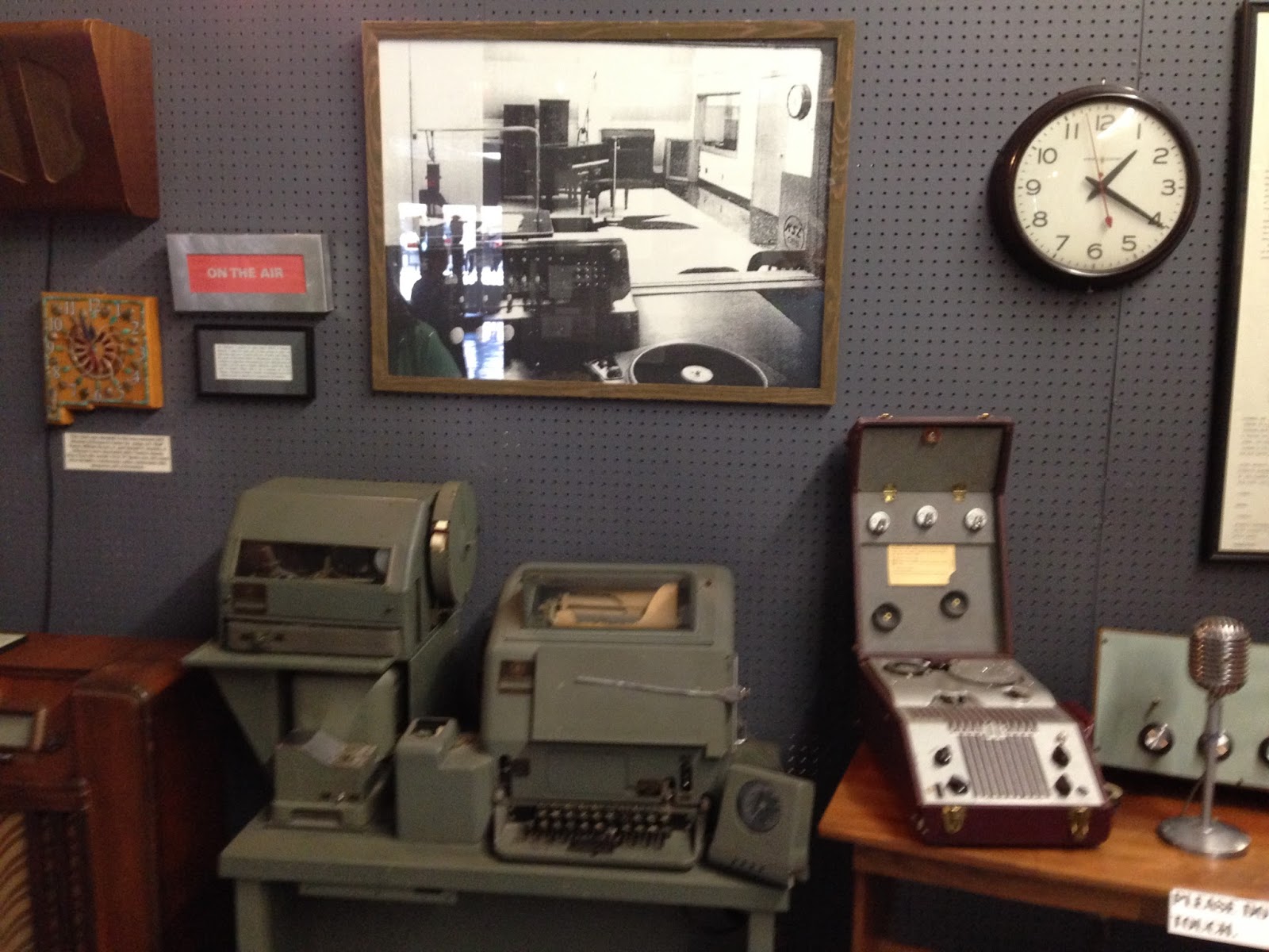
Roswell Radio Station mock-up with a green teletype from the era
Our goal today was to visit the International UFO Museum and Research Center in Roswell. It is downtown, right on US 285 on the right side of the street. It appears to be an old theater that has been remodeled to hold the museum exhibits and displays. Once you pay, the tour is self guided and it can take a long time to read everything. The walls are covered with photos and displays, sworn testimonies about what people had witnessed and many pages of denials from different government officials, plus supposedly real government materials about how to handle alien investigations.

Vintage Western Chicago wire audio recorder (before audio tape was invented)

Crash site items with strange writing and metals
They have a teletype from the era like the one where the news report of the incident was stopped by the FBI, a radio station display with a rare wire audio recorder and a recording of the broadcast of the incident playing at the push of a button. A video theater plays recorded cable television UFO programs all day. An alien site mock-up with fog and lights runs at certain times. Photos cover wall after wall include sightings, various evidence, crops circles, native American art, a prop from the film "The Day The Earth Stood Still", and more. Certainly the people who have donated and collected these things are very serious.

The Day The Earth Stood Still

The great cover-up as the Government denies the alien story

Alien photo evidence from around the world

Items here include things found implanted in people

Crop Circles from around the world
The Research Center holds a library with reading and study areas and is open to anyone looking to research UFO's.
After our tour we visited an antique mall and the local art museum. The drive back was just as long and empty as the drive here. Eventually we returned to Santa Fe for the night.
Whatever actually happened in Roswell in 1947 may have been so successfully covered up and distorted by our government, we may never know the truth. Roswell is a fun and interesting place to visit and UFO's have become an important part of our American culture.

Movie props from a 1994 film about Roswell
To find Roswell, drive south from Santa Fe, NM on US 285 across almost empty land for almost 200 miles. Fill up before you go. It is well worth the trip!

Friday, August 28, 2015

New Mexico Road Trip Planning

Inside Loretta Chapel in Santa Fe
I had planned to get out a few days with my wife and enjoy the New Mexico scenery. We only had 4 days for the entire trip and had to really keep our expenses low. I planned to travel to 4 different areas where we could enjoy the sites and scenery and actually spend a little time in the great outdoors. Santa Fe would be the hub. Hotel planning came last and we found a room in Santa Fe online for 3 nights for a great rate, with breakfast!
We packed lunch and snacks, our backpacks, my plan and drove. No backpacking, but plenty of cool places to visit.
Day 1 - Drive to Pueblo, CO and tour the River Walk. Continue to Trinidad and tour the Baca and Bloom houses and History Center. Drive south to Capulin Volcano National Monument. Drive to Santa Fe.
Day 2 - Drive to Roswell, NM and tour the International UFO Museum and the Arts Center. Return to Santa Fe.
Day 3 - Drive to Bandelier National Monument, visit Los Alamos having lunch with our friend Ruby, return to Santa Fe.
Day 4 - Visit Loretta Chapel, drive to Taos visiting the San Francisco De Assisi church and Kit Carsons home, drive through Cimaron Canyon State Park, returning home to Castle Rock.
Whew! That is a lot of driving! But it does get us in the great outdoors, into historic sites and gets us a needed vacation.
You have already read about Capulin Volcano, check out the rest of our Road Trip in the upcoming weeks.

Friday, August 21, 2015

Road Trip - Capulin Volcano National Monument

The Volcano Rim
Capulin Volcano National Monument sits in New Mexico's northeastern corner, about 30 miles west of Raton, NM off US 64/87 and NM 325. I found it while searching Google Maps a few years ago and was excited to visit the 800 acre park.
About 60,000 years ago, Capulin Volcano erupted, forming the cinder cone volcano we see today. This area is home to the 8000 square mile Raton-Clayton volcanic field. The cinder cone rises over 1300 feet above the plains to reach 8,182 feet elevation. Mostly made up of loose cinders, ash and other rock debris from the eruption, Capulin preserved its cone-like symmetry because the later volcanic flows came from its boca (spanish for mouth) at the cones western base. Mountains all around are capped with volcanic ash and tuft.
They say Capulin is "extinct" but I have my doubts. I believe we live in a worldwide volcanic 'pause' that may someday restart. When that day will come, who knows. Regardless, I chanced it and drove to the volcano's top and descended into its crater on a short hike.

Looking west across New Mexico from the rim
The visitor center at the bottom of the volcano is where you pay the $7 per car admission. There are displays with the site history, a film, bookstore and restrooms. Picnic tables are near the parking lot. To get to the top you must drive. No trailers are allowed. Closed only on Thanksgiving, Christmas and New Years day. Open 8 AM to 4:30 PM, and until 5 PM during the summer months. After closing, you may walk or bicycle the road to the rim of the volcano.  Pick up a trail guide and hike one of the lava flow or boca trails from the visitor center to learn more about the volcano.
Local legend says that Capulin was named for the Spanish word for chokecherry, which grows throughout the park along with mountain mahogany, scrub oak and three-leaf sumac. Chokecherry pies are an awesome local treat, if you have never had one. Pinyon pine, juniper and ponderosa pine grow throughout the park along with prairie grasses and abundant wildflowers. From the volcano top you can see New Mexico, Colorado, Texas and Oklahoma on a clear day. The views from the parking area are nice too!

Windy photo of yours truly from inside the crater, next to the vent
We hiked down a steep but short trail to the crater. Near the bottom, the volcanic rocks look rough and gnarly. The wind was swirling down into the crater. While being really cool, it also had a strange feeling there. I pulled out my iPhone and opened the compass app. After it loaded, it showed north was actually pointing east about 50 degrees. I walked partly back from the vent, closed and re-opened the app and got the same reading. At the visitor center, the ranger confirmed my findings, saying the mass of volcanic rock would effect all compasses this way. Interesting! By the way, the views and trails along the volcano rim are awesome, and I can now say I have hiked to a volcanic vent, inside the crater. However, for those with a fear of high places, you may want someone else to drive you up the steep corkscrew road with no guardrails. Built in 1925, it will require a little nerve to safely drive to the top.

Inside the Capulin crater
To get to Capulin Volcano, from Denver go south on I-25, exiting at Raton, NM. Follow US64/87 east 28 miles to the village of Capulin, turning north on NM325 for 3 miles. The park entrance is well signed and is on the right. On NM325, watch for cattle crossings as they can be rough if you are driving too fast. There were no services in Capulin when we were there, so plan for gas and food in Raton.

Looking north from the rim

Saturday, August 1, 2015

Bicycling the Cherry Creek Trail

Cherry Creek
I had not been hiking or bicycling much the past few weeks due mostly to my schedule, so instead of planting myself in front of the computer screen all day, I went for a bicycle ride along the southern end of the Cherry Creek Trail.  A map is available HERE.
I unloaded my bike at the Hidden Mesa Trailhead just north of Franktown on CO 83.  The park was quite busy over to the left with people working in the greenhouses and tending the flowers and plants around the log cabin in the parking lot.
I rode down the dirt farm path toward Cherry Creek, crossed the bridge and joined up with the Cherry Creek Trail at the half mile mark.  My hybrid bicycle navigated the dirt path just fine.
From here, I followed the trail less used, turning south to see for myself if the trail reached Castlewood Canyon State Park.  The plan with building the trail had been to connect Denver and the Cherry Creek State Park with Castlewood Canyon State Park, some 40+ miles to the south.  Many years ago, I had once tried to bicycle the Trail from my home in Castle Rock all the way to Confluence Park at the junction of Cherry Creek and the Platte River in downtown Denver.  What I found then were dead ends, long re-routes around private land all along the trail and lots of road riding throughout Douglas and Arapaho Counties.  The few miles of the trail from the Platte River Junction to Cherry Creek State Park were in place at the time and were a nice ride, finishing at the then new REI store.

Farmland along the trail
Today I followed alongside some hills I had never noticed before and passed through farmland with baled hay drying in the field and "working ranches" while bicycling above and west of the creek. The trail then took a left down a dirt road and joined another gravel path along a water storage pond, then turned right back onto the paved trail again.  Passing through an area with some trees I spooked a flock of birds from the ground who squawked and chirped loudly, like they didn't expect me at all.  I also felt no one else had been here in some time, like I was an intruder in the birds paradise.

Dead End
I soon found out why, when I came to the trails end just south of the highway 86 bridge.  The trail just ended there and didn't offer any way out, no connection to Franktown or to CO 86.  I turned around a little disappointed after riding only 2.75 miles from the trailhead.  Oh well, maybe the land owner will allow the trail access to Castlewood Canyon Road, providing some closure and connection.

Frog and Beetle
39.5 Mile Marker
I turned around after photographing a frog and beetle on the pavement, and pedaled back north, crossing Cherry Creek, passing under CO 86, crossing the creek again and following the path through the trees.  After going left onto the gravel path, I realized a person could bicycle on the gravel road to the left out to CO 86, turn left, then follow the highway about half a mile and turn right onto Castlewood Canyon Road to get to the park.  While the trail was well signed to keep users on the path, there were no signs showing how to get to the park.

Promoting Hidden Mesa
I quickly passed the farm path and continued north, climbing a small hill.  The trail junction up to Hidden Mesa was at the top of the hill and was well marked.  I know from hiking there, my bicycle tires and gearing are a bit narrow and weak for the route, so I continued north.  Turning right you descend Castle Oaks Road to cross under the bridge.  This section I had just ridden had not existed when I lived here before, so now I was now riding somewhat familiar ground.
I followed along the trail here which travels through private land and has some gates to be opened and closed.  Today all gates were open, no cattle were grazing here and the trail was smooth and fast. I bicycled past Bayou Gulch and the new connector trail to highway 83, then was routed behind a neighborhood that had just started construction when I rode there before.  At the end of the neighborhood, I left the trail to follow a gravel path east and up to another gravel farm road where I turned left and pedaled by another field and some farmhouses.  There are development signs everywhere along here, announcing this former farm will be developed into another neighborhood. While sad, it is inevitable that any wide open place like this will either become a neighborhood or an open space park.  The neighborhoods are winning.

Looking east across the old wooden bridge
I turned left again to go around the north side of the farm, this time onto another gravel path that crossed a wooden bridge.  The worn boards were rough with bent nails protruding from the railroad tie-like logs.  Cars are forbidden to cross this bridge and it may be one of the last wooden farm bridges left in the area.  On the good news side, the Cherry Creek Trail will most likely be completed through the future development, removing the farm bypass.
The paved trail continues along across more farm land, passes the side trail to the Pinery and continues to follow Cherry Creek northward.  My goal today was to ride to Stroh Ranch Road and turn around there, giving me a 20 mile ride.  I turned around at the Stroh Road bridge and rode back south, planning to take a short break at a bench I passed.  It was a beautiful day today and was nice except for the headwind I encountered on the way back home.

Turnaround Point Trail Sign
Working Ranch Trail Signage
Break spot on the return trip
View from the break spot
Back to the farm path at trails end
Cherry Creek under the Farm Path Bridge
I was tired at the end of the ride and was happy to be out of the wind.  I passed several bicyclists today, on both road and mountain bikes, and a couple people walking.  The trail was as nice as I remembered it and I hope to ride more of it again soon.
To start at the southern end of the Cherry Creek Trail, drive south from Denver on I-25, exiting at Founders Parkway, exit 184.  Go left and follow to CO 86 where you go left/east.  Drive to Franktown and turn left on CO 83 about a mile and a half to Hidden Mesa Open Space just past the historic Pikes Peak Grange.  Turn left into the parking area and start your ride here.  There is a porta-let, picnic tables and shelter here.  The parking area is open from 1 hour before sunrise to 1 hour after sunset.