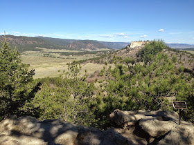
Friday, May 29, 2015

Dupont Open Space


Dupont Open Space Trail
Dupont Open Space near Louviers, CO is a peaceful and quiet riparian habitat beside Plum Creek, just west of US 85 (Santa Fe Trail) and north of Sedalia.   It was raining off and on when we hiked it this week.  The area is great for a nice walk.  The Open Space is packed with many different bird species and wildlife.

Deer

Plum Creek
During the rain, 3 does were eating in the tall grass, nervously watching us from behind the Russian Olive and Cottonwood trees.
Hiking the trail could have gone on longer but the rain drove us back to our car.  We will come back when the weather clears and hike some more.

The park-like Open Space with dark skies

Flowers are everywhere

Enchanting forest inviting you in
Afterward we toured the Dupont company town site of Louviers.  Built in 1908, most of the homes were well kept and the Village Center was in great shape.  A couple homes are new, but most are older and are in a style more eastern than western.  I grew up around the coal company towns in eastern Kentucky, and this place felt like that.
Douglas County Library and a bowling alley are also in the Village Center.  Here is a wealth of historical information about the area.

Last look from the safety of the car in the rain
Finding Dupont Open Space is easy.  From Denver, travel south of 470 on Santa Fe US 85 for about 5 miles.  After the road changes from 4 lane to 2 lane, look for a sign pointing to Louviers on the right.  This is just past a very large travel trailer storage site.  Turn right, cross the railroad tracks and follow Main Street around to the right.  Cross the second set of railroad tracks and follow to the bridge over Plum Creek.  Park in the roadside area just past the bridge and cross the street to the trailhead pictured above. The Town of Louviers is just down the road about half a mile.

Friday, May 22, 2015

Hike Planning for Castlewood Canyon State Park

Castlewood Canyon State Park
Castlewood Canyon State Park lies just east of Castle Rock and is accessible from both highway 83 and highway 86.  Hiking trails range from one half a mile to 4 miles in length. Inside the canyon there are ruins of the old dam that held back Castlewood Lake and a historic pioneers homestead. Scenic trails run from canyon top to canyon bottom, and follow Cherry Creek.  Bicycling is allowed only on the roads, Castlewood Canyon road being a nice loop route from Castle Rock.

Denver Post photo of the flooding
Castlewood Dam was built in 1890 on Cherry Creek across a canyon 5 miles south of Franktown in Douglas County.  The rock-filled structure was built by the Denver Water Storage Company.  The dam was built like others in that time, using the weight of the rock rubble inside the dam to hold back the 5300 acre feet of water the reservoir was to hold. The dam was built 50 feet thick at the bottom, 8 feet thick at the top, spanned 600 feet at 70 feet high.  Of course the dam leaked from the start.  The shifting sandstone strata under the dam caused many leaks and may have caused its failure 43 years later.  The plan was to provide water for some 30,000 acres downstream. Arguments about the dam's safety raged for decades.
Flood wall reaches Denver
It was early August of 1933 when successive days of rain caused the 43 year old Castlewood Dam to fail, sending a 15 foot high wave of water all the way through Denver. The sound of the dam bursting was heard 2 miles away as a mile-wide wave roared down the Cheery Creek valley, past Franktown and Parker, killing two people.  The debris-filled water washed out 6 bridges in quick succession when it reached Denver, flooding homes, causing power and phone lines to be cut.  Police sirens and telephone operators are credited with saving many lives as hundreds wearing only their night clothes fled in automobiles to higher ground.  Property damage was estimated at $1,000,000 from the billion gallon deluge along the 35 mile path of destruction.  The historic photos of the flood show the wall of water, estimated from 11 to 15 feet high, plus all the damage, destroyed bridges, flooded farmland, homes and businesses.  Read the personal accounts of the flood HERE.  


Trailhead for Homestead Trail around the historic Lucas Homestead
Today Castlewood Canyon is a peaceful place, with 30 picnic sites, 14 miles of quiet hiking trails, 60 foot high climbing walls (with some restrictions), offering birding and wildlife viewing.   There is no camping but picnicing is king here with 3 reservable group shelters available.  The family-oriented visitor center hosts videos on wildlife and nature.  A list of hiking trails and a map are HERE.
There are hiking trails along the Cherry Creek bottom, on top of the mesa above the creek, around the dam, and east along Cherry Creek from the main park area on highway 83. My favorite hike is the Creek Bottom Trail, about 1.7 miles, starting at 6200 feet elevation. This riparian area is beautiful with trees and shrub, birds and wildlife and the canyon walls, along with a small waterfall.
Finding the park is easy.  From Denver, head south on I-25 to exit 182, go east on highway 86 for 4 miles to Franktown.  Turn right/south on highway 83 and drive 5 miles to the park entrance on the right. Alternately, you can enter the west gate from highway 86.  Turn right onto Castlewood Canyon Road prior to crossing Cherry Creek bridge about a quarter mile west of Franktown.  Follow the road south to the entrance.  This road becomes dirt once inside the park.

Friday, May 15, 2015

Hike Planning for Mueller State Park

Pikes Peak from Mueller State Park
Mueller State Park sits just west of Pikes Peak and south of Divide.  Most of the park is at 9600 feet above sea level and the park encompasses 5121 acres situated in trees.  In the past the area was just passed through by native Americans and trappers.  In the 1860's there were about 50,000 people living in the area, many searching for riches at Cripple Creek.
Geologically, the Precambrian Pikes Peak granite lies underneath the park with a couple old fault lines running through the area.  Nearby are Florissant Fossil beds, Molly Kathleen Gold Mine and the Gold Belt Scenic Byway Tour, so there is much to see and do in the region.
Entrance fees are $7 a day, with camping for tents-only $16 and $20 for RV's with electric.
19 miles of trails are set aside for mountain biking, and 55 miles of trails are open for hiking.  There are also horses available for riding the 27 miles of horse trails.  All of these trails are considered "moderate" or "steep".   There are no backcountry campsites (or backpacking), all camping, cabins and yurts are within the front area of the park.  For hiking, a trail map is available HERE.  Most trails are multi-use.
Mueller camp sites
We camped here with friends years ago and had a great time with the kids.  The campsites are treed, with pines and some aspen, and ours was open to a meadow.  There are 132 camping sites, most with electric outlets.  Coin showers are available.  Do get a camping reservation because these sites fill fast.
There is a fine welcome center at Big View Overlook and several family-friendly and more difficult trails start there.  Pick up a trail map before heading out.
Wildlife viewing is good with opportunities to see mule deer, black bear, elk, mountain lions and hawks.  Photography is great here.
Winter is also an excellent time to tour the park by cross-country ski or snowshoes.  We hiked for miles in the backcountry in snowshoes and had the place to ourselves.

Pikes Peak granite

Friday, May 8, 2015

Setting up the Tent


Setting Up The Tent


2 person REI Half Dome Tent
Setting up your tent can be pretty easy.  I have only one rule.
Rule #1 – Setup the tent in your yard before you go on a trip with it.  
If you have already setup your tent, you will know where the poles and stakes go.  Setting up tents is mostly about how good your memory is, and that will improve the more you do it.  Whether you pitch a solo tent for just yourself, a 2-person tent for you and spouse, or an 8-person tent for the whole family, the poles will go together only a certain way.  Some tents you stake out first, others you stake out last.
This detail is all in the tent’s directions, which you must read before you setup the tent in your yard the first time. Keep the directions with the tent for next year when you go camping again and can’t remember how to set it up.  Also keep everything that goes with the tent in their bags together.  That way you won’t arrive at camp without an important part of the tent poles.
When you return from the trip, hang the tent up in the garage or on the back porch to let it fully dry out. When dry, repack everything together, checking to see you have all the parts.
For CaRV Camping, remember to bring along a stake hammer to pound the stakes into the hard, packed soil of the campsite.  You can also use the hammer to pull the stakes back up when you leave.
Any questions, see Rule #1.

Friday, May 1, 2015

Spruce Mountain Open Space Trail

Spruce Mountain Open Space Trailhead.  Greenland is a great open area south of Larkspur
Spruce Mountain Open Space Trail runs about 8 miles and climbs a forested flat-topped mountain in southern Douglas County Colorado.  Similar to other multi-use trails in the county, Spruce Mountain used to be a wayside on old highway 85, called the Santa Fe Trail, about 6 miles south of Larkspur, Colorado.  On many bike rides I paused at the mountain's base, looking out over the great open expanse of land running south and east.  Thanks to groups like Colorado Outdoors and the Colorado Lottery, land like this plus miles of open grassland have been set aside to enjoy "as-is" forever.

Looking north across the meadow to Monkey Face Butte at Larkspur
Looking up the Oak Shortcut trail to the Greenland Overlook
Go straight on the Oak Shortcut trail or go left.  Both climb Spruce Mountain
The trail head is in a parking lot at an elevation of 7100 feet.  From there you can easily climb up switchbacks along the trail to the Windy Point overlook at 7605 feet above sea level.  The trail is natural sandy surface and is shaded.  It runs through thick woods for most of the way.  Mountain Bikes are welcome here and along the Spruce Meadows Trails throughout the open space north, east and southeast of Spruce Mountain.  Horseback riders are welcome too!  The meadow trails run for 8.5 miles.

Pine Junction Trail Sign
The Greenland Overlook
The first climb is about 100 feet to Pine Junction where a shorter and steeper trail called Oak Shortcut runs from the parking lot (go south instead of west).  My wife and I took advantage of the great weather and hiked the Spruce Mountain trail in this direction this time.  While this trail was OK for reducing trail time on the uphill climb, it is so steep that coming down the trail may lead to slips and erosion. Plus our knees enjoyed the more mellow altitude loss of the longer trail on the way back down. The way we hiked today, the trail was just under 5 miles.
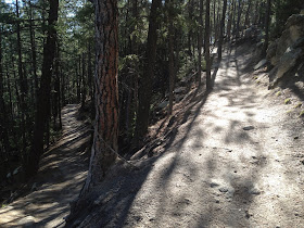
Switchbacks
There are two switchbacks below this one
Climbing switchbacks, the trail ascends past Greenland overlook.  Greenland is the group of ranches to the east of Spruce Mountain in the meadow and is Douglas County Open Space along both the east and west sides of I-25.
Further along, the trail splits at a jut in the trail out to the northwest so horseback riders can get by the overhanging rocks.  Here there is a marker celebrating Paddock's Point, for Warren Craig Paddock who practiced forestry and loved Spruce Mountain. Once you reach the upper loop road you will see that trees have been selectively cut from the mountain top, like someone used a measuring tape to cut the same size trees.  Just look around the area at how trees were selectively thinned, but never clear-cut.  Wood chips on the ground show they were trimmed and logged in select areas before being taken out along the road.  Thanks to Mr. Paddock for taking great care of the land.

View south with snow-covered Pikes Peak behind the front range foothills
Thanks to Mr. Paddock for his forestry service and love of Spruce Mountain
Eagle Mountain, to the north of Spruce Mountain, is part of a private conservation easement
We hiked on up to the upper loop junction at around 7400 feet.  There the trail joins an old service road which loops the mountain.  This loop travels through forest and undulates up and down past rocks and hoodoos.  There are three picnic tables spaced along here at overlooks with great views. Bring lunch and make it a day!

When you need a rest, there is a bench nearby
What an awesome trail!  You can smell the spruce and pines
Views amid hoodoos
Views south to Palmer Lake
One of 3 picnic benches placed about 2/3 of the way to Windy Point
Tree death by lightning.  Beware!
At 1.5 miles of the mountain top road, the loop road passes Windy Point, the southernmost part of the mountain top.  Here the views were exceptional.  Today there was no wind, but with this rock outcropping so near the Palmer Divide (Palmer Lake is the town you see below) this area could be incredibly windy with the weather changing rapidly.  Most severe storms are steered by the Palmer Divide, variously going either north or south.  The weather here still troubles meteorologists and ranchers alike today because they cannot tell which way the storm will go until the last moment when it passes the divide.

Usually it is windy here
Palmer Lake at the Palmer Divide
Interesting stone circle with a stone in the center
One last view southeast before turning north.  You can see the Black Forest from here
We turned back north along the loop road and enjoyed a beautiful view of the Colorado Front Range extending past Long's Peak.  We continued to enjoy the walk along the mountain top park.  The precisely thinned trees, mossy boulders and gently undulating ground looked like a professionally trimmed lawn.  Birds flitted from pine tree to pine tree, the air was heavy with scented spruce and pine, spring wildflowers began their blooms, damp moss covered shady parts of the ground, grasshoppers flitted about our legs.

Looking north into the red rocks of Perry Park
More awesome upper loop hiking
The service road down to Eagle Pass Trail
Wildflower lit just for me
About a third of a mile past Windy Point, we came to the service road which leads to the bottom of the hill on the west side of the mountain.  It was steep and we were enjoying the mountain top so much, we just continued along the loop road.  At the bottom of the hill this road connects to the east with the Eagle Pass Trail and Spruce Meadows trails along the open space in the grassland.  It also leads west to a picnic table and (I have heard but have not seen) a pioneer grave site.  I will come back to hike that trail portion another time.
Our trail sign to go back downhill.  The Slow Down sign is for mountain bikers
More wildflowers
Erosion in this sandy soil is a very bad thing.  Please stay on the trail
Trail on the way back down
Back side of the Oak Shortcut trail sign
We finally reached the Upper Loop Junction trail sign and headed back downhill.  We enjoyed the peacefulness of the trail.  We made our way back down to the trailhead and the awaiting (and hot) car.  What a great hike this was!
To find Spruce Mountain Open Space, go south from Denver on I-25 and exit at #173 Larkspur. Watch your speed going through town, they are serious about you driving 25 MPH.  Travel south 6 miles on Spruce Mountain Road.  The trailhead is one mile on the right past Noe Road.  To visit the Spruce Meadows Trailhead, turn left (east) on Noe Road and go 1.5 miles.  Pets are welcome but must be on a leash.  The trail is open from 1 hour before sunrise to 1 hour after sunset.  No camping is allowed.