Friday, December 26, 2014

Daniels Park


My favorite stone picnic shelter, designed by J. Benedict in 1922
Some of the Denver areas best mountain views are found in the older Denver Mountain Parks.  Daniels Park, south of Denver keeps this promise, providing an unlimited view of the entire front range, from north of Longs Peak to the south at Pikes Peak.
Denver Mountain Parks began as an idea in 1909-1910 by John Brisben Walker and Robert W. Speer, Denver's mayor.  The idea not only included parks, but roads to connect them, so everyone could travel to the parks easily.  Over many years it grew into the huge park system we now know, including Winter Park and O'Fallon Park.  The famous landscape architect, Frederick Law Olmsted, was hired in 1912 and he planned the system of mountain roads and parkland of 41,310 acres. Genesee Park was the first to be developed, Red Rocks Park among the last in 1927-1928.  There is much history here, and a few of the great, local auto-tours to enjoy also.
The best picnic is from the picnic table on the edge of the bluff

One of my favorite stone picnic shelters is here, designed by J.J.B. Benedict in 1922.  It's use of native stone and timbers is wonderful.  While they have sealed up the fireplace, it is still nice to sit on the old stones and ponder the view.
The bison (native buffalo) herd here is also pretty neat to watch.  It was transplanted here from the herd in Genesee Park in 1939.  You can see how huge these animals are.
Looking north along the front range to Wyoming.  Bring your telephoto lens for mountain close-ups.

The view goes on forever.  The day we were here there was no wind at all, not even a breeze.  That is unusual, as it is almost always very windy here.
Hiking in the park is available as trails along the bison fence and the views above the bluffs.  It is still very pleasant here, a nice diversion from the fast pace slam of the Interstate.  It is a good place to rest and look out at the geologic wonder of the front range of Colorado.
To get to Daniels Park, go south on I-25 from Denver, exit at #188, Castle Pines.  Travel west on Castle Pines Parkway, turning right onto North Daniels Park Road.  The picnic shelter is on your left at Wildcat Point, bison are in  the fields to your right.

Friday, December 19, 2014

Gateway Mesa Open Space


The Trail Head with my shadow 
Sometimes you find a trail that is just right.  For a nice, mostly flat 2 mile hike along a mesa top in Castle Rock, I found the Gateway Mesa Trail.  We hiked Chucks Loop, a 1.8 mile trail which crosses the mesa to the bluffs overlooking Franktown and Cherry Creek.  This is that same Cherry Creek that flows north, where the town of Denver began at Cherry Creek's confluence with the Platte River.
The trail follows along a horse farm fence for half a mile before coming to the cap rock area near the bluffs.  Here the Mitchell Creek Canyon Trail intersects Chuck's Loop.  We hiked south along this trail another half mile and stopped to enjoy the view at an overlook.

The overlook, Franktown below
More overlook.  It all drops away from the cap rock
Cap Rock.  This looks just like you are on top of Castle Rock, except for the trees

Pikes Peak

We walked back north to rejoin Chuck's Loop Trail.  The plan is to tackle Mitchell Creek Canyon Trail on another day.  Back on the main loop, we followed the trail along the cap rock via cairns.
With more trees in this area, bird life was everywhere.  From smaller than a couple fingers to full size hunting hawks, there were so many different types of birds I needed an identification book to name them.
Cairns
Hoodoos

An old gnarly cedar
Hoodoos, old and gnarly cedar trees, and a few well-placed wooden benches, this trail was interesting.  Once we got as far back as the bluff area, all sounds of traffic had disappeared and with only the sound of the wind in the trees, it was very peaceful.

Trees, Clear Sky and the Colorado Sunshine
Benches provided by an Eagle Scout Project
A cute door knocker added to a tree
Juniper berries, more than I have ever seen.  That's why there are so many birds here
We sat on a bench and enjoyed the solitude as the trail rose out of the trees and into a meadow.  There were remains of a barb wire fence to the right, lots of different grasses and the distant mountains to ponder.  I really like this trail!

A long view of Longs Peak and the front range.
And Mount Evans

A close-up of the grass
And more back-lit scrub and grasses
The trail follows along, well-marked and easy.  When wet there could be some mud, but it is mostly natural surface and rock.  We encountered some traffic noise as we rounded the north side of the trail from highway 86 and headed back to the Trail Head.  

A bluebird house.  Many were built along the trail
That small dot in the sky is the rising moon
Parting shot at the end of a fine hike
The Trail Head is located on highway 86, as you travel east from Castle Rock to Franktown, and is the last turn off to the right before dropping down to Cherry Creek.  Since the trail is short, you can hike it in less than 2 hours and still take your time.

Friday, December 12, 2014

The MAC - Purple Trail Loop


The MAC from the Purple Trail.  The Challenge Trail climbs to the top of the ridge
Today's hike was along the Purple Loop Trail at the MAC in Castle Rock.
This natural surface trail climbs quickly and provides views of Castle Rock and the new MAC site. This is the shortest of the 5 hiking/bicycling trails and it is interconnected to the Gold Loop Trail, the Red Loop Trail and the Green Loop Trail, all of which add up to over 8 miles of hilly hiking or bicycling.  This trail starts to the north of the site and is across the street from the Challenge Hill, a 200-step staircase similar in design to the Manitou Springs Incline. Challenge Hill also has the Blue Loop Trail which climbs to the top, in case you need a break from the steps.
The community park site includes a zip-line course and an adventure playground area.  The MAC is a world-class fitness facility with indoor and outdoor lighted synthetic surface fields, activity classes, a pool, classes of workout routines, a golf simulator and a trampoline.
Awesome new trail construction
Trail construction is recent and is done well with water bars and a downhill slanted trail bed for drainage.  Some sections are steep, so you need to watch your step and not slip-slide away.  A couple in front of us slipped into a trail side cactus on the loose gravel, so do be careful.
Mostly scrub cover, there is a little shade along the north side near the top of the ridge
The weather "is what it is" this week with the temperatures in the lower 60's for our hike.  The sky is perfectly clear and from one vantage point, we could clearly see a sliver of mountains over 70 miles away.  Usually December is colder here, but we will take the clear, warm weather.  Our sea-level lungs are still adapting to the altitude, and we stopped to catch our breath a couple times.
The trail markers are colored per trail, this one showing the Purple Trail loop junction
The trail is shared with mountain bikers, and it has that straight-up/straight-down feeling of most off-road bicycle trails in Colorado.  Other than seeing that other couple, we had the trail and the views to ourselves for our peaceful walk.
Future plans call for connecting these trails to the Ridgeline Open Space and the Stuart Trail network to the west.
View of the ball fields (to the right of the first photo) and the towers for the upcoming zip lines
These trails are located at the new Phillip Miller Recreation center (or MAC for Miller Activity Complex) at 1375 West Plum Creek Parkway.  Parking and hiking are free.  You can access the center off Interstate 25 at Plum Creek Parkway.  Go uphill (west) and the MAC is that massive field house on the left.
Trail Head shows you the way back to the MAC.  I love these signs!

Friday, November 28, 2014

First Weeks West

Daytime view of Castle Rock from the Rec Center parking lot, through the windshield, zoomed in due to the cold.
In our first few weeks out west we have both been exposed to Colorado's unique weather extremes.
One of the greatest things about living out here (for us outdoors folks) is the close proximity to the mountains, prairie, forests, grasslands and deserts.  My goal is to try to get out each week, if only for a short drive, a hike or a snowshoe into the wild.
Weather can be a problem, and I'm not going to get in trouble being stranded in the snow and ice.  If it is too bad to get out, then I'll stay inside and keep my toes toasty by the fire.  And I will plan future trips.
Today's quick walk was along the Bowl walkway in the Meadows development of Castle Rock, across from the Rec Center.  We chose this paved urban area trail due to wanting to avoid Colorado's mud.  Castle Rocks trail descriptions and maps can be located HERE with more information about the community HERE.
The paved walkway winds up the hill and into some trees.  Note the snow clouds above.
It was 37 degrees and overcast when we started, and we were both under-dressed for the wind.  Snow was falling in Perry Park to the west, and you couldn't see the mountains for the snow falling in the north also.
The trail follows a drainage up the hill toward Founders Parkway.  It climbs to the top of the ridge going through and around a few housing developments.  There was some scrub oak and tall grass around, all in various browns.  Portions of grass poked through the snow on the ground, some of it was still green.  The pine trees were the tallest trees around and a few were specially placed by nature around stones and rocks.  The trail builders had provided tot-lot toys for children and a nice covered picnic area with built-in grills, a staircase and a volley ball area.  A squirrel dashed across the grass to a new hiding place.  Birds darted among the trees.  Houses didn't intrude on the trail and it was peaceful.  And cold.
A Bluebird house along the trail.
Both of us got too cold too quickly, and we beat a hasty retreat back to the warmth of the car.
While my upper body was warm enough, my hands and legs were freezing.  (Note to self - Silly man, jeans provide little to no warmth in windy, snowy weather).
Wearing the proper clothing is so important here, and we will have to invest in the proper outwear and water-proof boots.
Picnic Shelter.
My phone was cold and it's camera wouldn't focus or use the correct exposure settings.  I grabbed a couple shots along the walk, but had to give up on that also.
Not a relaxing walk today due to the lack of being prepared on our part, but I do remember smelling a pine tree as we passed it, the smell was so strong and pronounced.  I remember that smell from hiking in the mountain forests out here.  Special smells like that stay with you, for years after that first encounter.

Friday, November 14, 2014

New Home, Old Home

Castle Rock, Colorado from Plum Creek.
I moved back home to Colorado.  If I didn't get to tell you before I left, my sincere apologies.  Living in Florida had run its course, my contract job had ended and I just wanted to go back home and start over, so I did.
Actually, we did.  My wife moved with me, driving her loaded car behind mine.  Our goal is to both find jobs and work, rebuilding our lives, doing things we enjoy.
We came across some cool things along the route to here.  A new suspension bridge across the Mississippi river in St. Louis was a great surprise.  The windmills, towering 200 feet above the Kansas hills were an awesome sight.  Those along with the miles of tall windmills in eastern Colorado are the future, creating electricity from the constant winds.
Castle Rock was our home for 13 years where we raised our children and were involved in the community.  I loved the outdoors and the life along the front range of the rocky mountains and the prairie.  I had wanted to return here since I left over 10 years ago, and we finally did.
We arrived in Castle Rock a few nights ago and are acclimating to the shift change, dry weather, DST change, time zone change, and elevation increase (sea level to 6000 feet).  I actually breathe deeper here.
Today we walked along the Plum Creek Trail in town.
The late afternoon sun colored everything gold.
The late fall foliage was beautiful.
I don't know the name of this grass, but in the late fall it looks like back-lit snow.
The mile-long south bound coal train rolled by.
Plum Creek is dammed in a few places by beavers.
The returning engines from an earlier coal train, heading back north for more loaded rail cars.
The Russian Olive tree in an invasive species here.
Old rock work under the rail road line.
Big Sky Country.  A change in the weather is coming tonight.
The trail returning to the parking lot with the setting sun. 


Friday, October 31, 2014

Hiker Progress

Somewhere on the Florida Trail

Here's an update on my injured knee.
After a week of walking a little then hobbling a lot, I am now hobbling very little and walking much better.  While waiting on car work today I walked around a wholesale store for over an hour, looking at everything.  I even went down rows where there was nothing to interest me.  It felt good to just walk.  Not that my knee is perfectly healed, but at least I can maneuver around shoppers and carts and not have to grab for something every time I turn.  This healing is real improvement, and though it is slow I am very pleased with it.
I had been planning a backpacking trip for November, but will have to put that off until I am comfortable with walking again.  My goal is to backpack at least 10-15 miles at a time, before stopping to camp, and doing the same miles again the next day. I am concerned about uneven surfaces, balance and big steps, like going over logs and fallen trees.
Getting out won't be easy for me next week either, all my time is already scheduled.  Maybe I can go for a morning walk outdoors enjoying the cool temps.  At least the Florida weather will cool down over the weekend with lows in the 50's and highs in the low 70's.  The weather here will be nice.  If you can get outside, this is the time to do it here.  Enjoy!

Friday, October 24, 2014

Colorado Summer Hikes I Miss

It is that autumn time of the year when I really miss hiking in the Colorado Mountains!  The snow is (mostly) gone from mountain trails, the days are cool and the stars are awesome on moonless nights.
My family would travel to Rocky Mountain National Park often to enjoy Trail Ridge Road with views of the Never Summer Mountains.
The Great Sand Dunes National Park was another favorite, along with summer road trips throughout the region to the Western Slope, Steamboat Springs, and Mesa Verde near Durango.  Also riding the narrow gauge railroads and learning about the local history was awesome!  The backwoods drives were beautiful with so much to see, my wife often reminded me to keep my eyes on the road.
Check out these 5 inspiring Colorado trails and trips to get a taste of what it is like there.

Friday, October 17, 2014

I Left My Heart At Wounded Knee

I hurt my knee again 2 years ago when I broke my hip and it has only gotten worse with popping and unsteadiness when walking.  The pain is minimal, but it can still really hurt if I somehow twist it the wrong way.
Walking along the Sanford River Walk by Lake Monroe
As a hiker/backpacker/bicyclist/walker my knees are incredibly important to my personal forms of travel.   Being unable to walk or bicycle much without my knee popping and being unsteady during the super-hot summer was just bearable.
I have been to a doctor and to a knee specialist while trying to fix it.  Fortunately the X-Ray and MRI show damage there is minimal, not requiring surgery.  But still the popping and unsteadiness continue. 
I was given a shot of Cortizone in the knee last week, and I am exercising it again and am really trying to improve my walking situation.  I was able to walk 3 miles along the waterfront in Sanford last weekend without any pain and with only a little weakness.
My plan is to just continue exercising and walking, increasing distance daily and weekly until I'm back up to my 15+ miles of off pavement travel in a day.  I figure that if I can make it to that goal of 15 miles a day, I can eventually make 20-25 miles of continuous hiking/backpacking/walking that I'll need to do in order to hike a long trail like the AT.  Of course that is a long way off.  If I'm able to backpack again on over night trips with my ultralight backpack (9 pounds base weight) by late winter/early spring I will be a happy hiker!
For bicycling, I will focus on riding the indoor bicycle in the gym, moving to my mountain bike for short rides outdoors.  20 miles is the distance I had been riding recently, so I will work on increasing that distance closer to the summertime.  While not my 200 mile week rides of old, I am just happy to be out there again.
Please bear with me while I take baby steps to get better, I believe it will all pay off in the end.
The good news is the temperatures in Florida are much cooler now and if the rain holds off, I will be able to walk and bicycle enough to slowly improve my condition. 

Friday, October 10, 2014

Fall is Here!

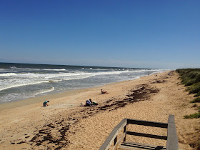
Looking north along the Atlantic Ocean.  Notice the hotels?  Nope.
Finally the fall weather has arrived in central Florida!
Last Sunday it was 62 degrees when I got going.  There was a cool breeze and the sky was crystal clear.  It even sounded different, like it does when the weather first changes temperature.
I drove to meet my friend Walt who cooked both of us a delicious breakfast with lots of hot coffee. Then we headed east to New Smyrna Beach where we raised a drink to the surf before driving south to Canaveral National Seashore.  Walt had just turned 62 this year and got us into the park for free with his new pass.  We drove in free and cruised along the coastal dune to the turnaround at the end of 6 paved miles.
And looking south, no hotels here either!
The car windows were open and we sat enjoying the cool wind waiting on a parking space, listening to the waves crash below.  After a few minutes waiting we drove back north to the next available parking space and walked down to the beach on the boardwalk.  Just watching the waves rush in and out was fine for me.  We waved at the Park Rangers and the people walking by, watched the surf fishermen cast lines about and followed the gulls as they flew overhead in the breeze.  This was nice.  No bugs, no heat and actually the wind was a bit chilly without a second shirt on.  I could stand here all day, leaning against the dry wooden rails and just stare out to sea.
The State House
Comfortable rockers!
An explosion of plant life above with Resurrection Ferns in the Live Oaks
The view from the rocking chairs.
Coral Honeysuckle, a Florida variety.  It doesn't smell as strong as northern varieties.
We drove up to the restored State House where we sat in the porch rockers watching the boat traffic and fishing people along the Intracoastal Waterway in Mosquito Lagoon.  Crowds came and went.  More birds flew by.  I noticed our conversation had gone quiet as we contemplated life's details.  I could also sit here, rocking all day, quietly.  It was nice to get peaceful.   One of the neatest things about using the free entrance pass is you don't feel you have to spend your every moment living to the fullest anymore.  You don't have to hike all the trails or get a line in the water to fish or see all the museums and displays.  You can slow down and just enjoy a short drive in a cool place that you probably wouldn't take before.
Intracoastal Waterway looking north from JB's
After a couple hours, a couple conversations and talking about a couple of dreams, we left and drove north to have lunch at JB's, a favorite eating stop along the barrier island. We waited a while after lunch on the dock, again just watching and listening.  There are some days I need to do just that and nothing else and today was that day.  I celebrated the end of summer's heat and bugs by leaning back and doing very little.  To end today with a quote, that made all the difference.