|
| King Lake |
It was an all uphill walk today, about 2800 feet of elevation gain over 6 miles of rocky trail to reach
King Lake in the Indian Peaks Wilderness Area, a classic Colorado Front Range backpacking trip. The write-ups of this iconic area I have been reading go back to the 1970's, but the latest by
Paul Mags, the writer of the Colorado Trail End To End Guide, while short are the best.
I am joined by my friend, David, who has summited all the Colorado 14ers (before he was 40). David is also a distance bicyclist, finishing Ride The Rockies this summer, where we met while I was volunteering. David is a great person, is very kind, has backpacking experience, and has taken me under his wing on these backpacking trips. He also carries and shares the tastiest trail snacks you could ever eat in the outdoors. I tease David about how light weight my ultralight backpack and gear is, but he just blows by me with his traditional pack and gear, smiling.
 |
| Breakfast at Ned's |
We drove the 75 miles through early morning rush hour traffic from Castle Rock toward Boulder where we turned off to follow Coal Creek Canyon to reach Nederland, near our trailhead. At the Ace Hardware in Nederland, we were taken through the National Forest Permit Process by Denise, who serviced us while the only hunting PC was overloaded with a line of waiting hunters. Asked about a good place for local breakfast, Denise said to check out Ned's or the New Moon Bakery. Ned's with the rusted violin player statue outside was awesome (named for Nederland), and after a fine home-cooked breakfast, we drove to the trailhead and parked in Eldora.
 |
| The path in to the trailhead is to the right of the often flooded rocky road. |
 |
| More cabins used to be here, mostly one rooms with outhouses out back |
If you have ever heard the story of the old dead guy kept in a freezer, Nederland is the town where Bredo Morstol is buried in a freezer inside a mountain top Tuff Shed. The next
Frozen Dead Guy Days festival is scheduled for March 10-12, 2017. Don't miss it!
The first part of the trail runs through the mostly abandoned ghost town of Hessie, after following a rough dirt road with a stream running down it. I have been here 3 times before on different day hikes, and there were more houses in Hessie then. I only went as far those times as Lost Lake, less than a quarter of the distance we will hike today.
 |
| Another Hessie home site |
 |
| Students measuring the stream |
 |
| And more getting water samples |
 |
| Hessie Trailhead |
 |
| The old sign |
 |
| Trail view |
After you pass most of the Hessie area, you cross the North Fork of Boulder Creek on a bridge where we passed some scientific study going on with a class of College students. The sky here is blue with some clouds, the temperature is quite warm. We swat mosquito's. The South Fork of Middle Boulder Creek will be our guide all day, beginning at the crest in snow-fed King Lake where we will camp just below 11,600 feet tonight. And so we start hiking uphill at this point, looping to the east, then back to the south before turning west while climbing a couple hundred feet along a rough rocky road. At the point where we turn west, people are day hiking with children and dogs, posing for photos with the falling creek behind them, and are already complaining of the steepness of the trail. This trail is rated from intermediate to difficult in the guidebooks.
 |
| The South Fork of Middle Boulder Creek will be our guide all day |
 |
| An unofficial campsite by the creek |
 |
| Family Photo Op |
Turning west you cross the South Fork of Middle Boulder Creek on a bridge, now following the creek uphill on your right. A photo op has been cleared for a waterfall view, the amount of water coming over the rocks is quite huge for August in Colorado, it was a trickle when I was here once in the summer. The road becomes corduroy, a layer of old railroad ties to hold the road from being washed away by the spring and early summer floods where the Middle Branch of Boulder Creek runs when the creek bed overflows down the road.
 |
| Bridge Crossing |
 |
| South Fork of Middle Boulder Creek |
 |
| Yet another view |
 |
| My friend David pausing at the bridge |
 |
| Corduroy Road |
We are walking along with a couple who are viewing birds with a shooting scope. A family of 6 passes us after another large family with dogs has already passed us, children running ahead. Two day hiking women with their dog pass us as we reach the turnoff for Lost Lake, a day hike favorite in this area, complete with old gold mining sites, a dozen National Forest campsites by the lake, and awesome mountain views. The Indian Peaks Wilderness Area is one of the busiest in the United States, but I have been unable to find actual counts of annual visitors for you. But the people we will see on the trail today is about to reduce drastically as we continue climbing up and west. Crossing the creek a third time, now on a two log bridge, we enter a meadow and soon cross into the actual Wilderness Area and pass the trail to Devil's Thumb and Woodland Lake.
 |
| Quite the volume of water and a popular photo spot |
 |
| The trees were removed for the photo op |
 |
| A black woolly bug, cold weather soon? |
 |
| Sign at Lost Lake, just a short uphill hike to the lake from here |
 |
| The wildflowers begin with Indian Paintbrush |
 |
| David walking ahead, Woodland Mountain to the right |
 |
| The two log bridge |
 |
| And the meadow beyond |
This is where the wildflowers begin. On this trip I enjoyed seeing more wildflowers than I have ever seen in Colorado. Ever, even in the spring. The large amount of rain we have had this year, plus the amount of not-yet-melted snowfall in this region has created a water-rich land area which has grown wildflowers by the gross. Wildflowers in reds, yellows, whites, purples and the Colorado Columbine, my favorite state flower, a wild iris I have rarely seen in the wild, is growing here in bunches.
Brian Mountain is in our view southerly through the trees, with Woodland Mountain rising on our right. Mountain top and cirque views to the west are hidden by the trees. We meander in and out of heavy tree cover and a beautiful layout of Colorado wildflowers.
 |
| Entering the actual Indian Peaks Wilderness Area |
 |
| The King Lake Trail |
 |
| A beetle kill area |
 |
| Nice grassy areas the trail runs through |
 |
| Brian Mountain to the south and west |
 |
| Old growth pine trees |
 |
| And Wildflowers |
The uphill hike is long, with views of Moffat's railroad twin trestles to the south poking through along the Guinn Mountain ridge above us (Rollins Pass is right next door). We are walking through a glacial moraine, with rocks of all sizes along the trail and rocks climbing to our right to form a ridge, falling to the still noisy creek to our left. Mostly hiking in shade, the trail cools us as the sky clouds up and rain begins; a light rain, a sprinkle, that cools without soaking like a lot of rains in Colorado do, my backpack getting wetter than my shirt as I continue to sweat in the cooling heat.
David is waiting for me, sitting under a thick trunk beside the trail, out of the rain. We sit and eat and drink. David hands me an apple he bought this morning, the sweetness of the apple tasting wonderful in the clear, clean, rain washed air. I estimate we are now at about 11,000 feet. With miles to go before I sleep, we continue walking uphill. Those 2 day hiking women from earlier pass us on the way back down.
 |
| The sky clouds up and sprinkles on us until evening |
 |
| The view through the forest |
 |
| My first Columbine of this trip |
 |
Note Moffat's Twin Trestles on the ridge above. This was the route used in 1906 to cross
into the Colorado Rockies going over Rollins Pass, and later the reason for the Moffat Tunnel |
 |
| Wildflowers galore |
 |
| And more wildflowers |
 |
| And more... |
 |
| And even more wildflowers |
Eventually we reach the really steep part of the trip, climbing switchbacks up to where the trail to Bob and Betty Lakes splits right and the King Lake trail goes left. While climbing up those switchbacks there is a large and dead Ponderosa Pine tree, split by lightning, leaning on another pine tree that creates a huge shaded area where I paused a few minutes, enjoying the coolness.
As I turn left at the trail junction to King Lake, I reach a stream crossing where the rocks to cross it are not spaced evenly or level enough for me to safely attempt, especially while wet. I rolled up my nylon pants, un-cliped my packs waist belt and sternum strap, and stepped into the ice-cold water. That was cold! While crossing the stream, I did slip on a submerged branch. I kept my balance, only getting one leg of my pants soaked, which I wrung out when I crossed the stream. I continued uphill, realizing the lake right in front of me was not King Lake, it was further ahead. David was ahead of me and once we caught up with each other, we searched for a camp site near King Lake.
 |
| Wildflowers to the right... |
 |
| ...and to the left of me. Yes, that's snow up there on the divide |
 |
| Last sign before King Lake |
 |
| Looking north |
The camping rules say we must be 100 feet, or 120 steps away from the lake. David found a nice flat space more than that away from the lake for his dome tent, just to the north. Snow was still lying very heavy in the cirque around the lake and around the other lakes and cirques nearby. I filtered water from King Lake, then set up my tent near Davids. Dinner was fixed an hour later, beside a rock to keep the stove out of the wind. The views here are awesome! We could see east to the plains through the haze, see all the cirques and mountain peaks west, north and south of us. As the sun set, the sky colors changed from pink to purple, the rocks changed from orange to red, then dark gray.
 |
| More Columbine! |
 |
| The view east, back along the way we came, krumholtz close |
 |
| Wildflowers along the paths of our camp site |
 |
| Filtering with the Sawyer at the lake |
 |
| Setting sun, view east |
 |
| Dinner in the cozy for 15 minutes, sipping my tea |
 |
| Sunset on the mountain as the clouds lift |
It was still partly cloudy and the rain had stopped. Later during the night the clouds parted, revealing the Milky Way running above us with so many stars, you couldn't make out any constellations at first. The Big Dipper was the first constellation I recognized, upside down and pouring out onto Devils Thumb to the north. The night was cool, with temps somewhere in the upper 40's. I slept well, staying inside my tent through sunrise, no wind blew that night.
Dinner was Knorr's noodles with Alfredo sauce and tuna. The noodles simmered about 5 minutes in my pot on the stove, then went into my pot cozy for 15 minutes along with the tuna. We split the hot steaming food and were both full. The ice cold water washed it all down. My wife had baked us oatmeal cookies with raisins for dessert. Get the noodle
recipe HERE and scroll down. While not as healthy as some of my organic camping meals, it was very filling, and eaten at 11,440 feet above sea level, it was a good dinner and a fine end to a long day of hiking uphill.
I awoke before sunrise, watching the sun come up from inside my tent. It was windy outside, and the tent vibrated with the air flow. I got dressed and walked around the campsite area, taking photos in the morning light. When David arose, we made coffee using the Starbucks Via packages he brought and ate lemon Laura Bars and fruit. We cleaned up and started back downhill the same way we came in, meeting a snow boarder and a hiker with his dog, both enjoying the mountain early.
 |
| Sunrise from the inside |
 |
| Looking northeast |
 |
| Looking north |
 |
| Slightly northwest along the Continental Divide, lots of snow |
 |
| West, King Lake is below the scrub |
 |
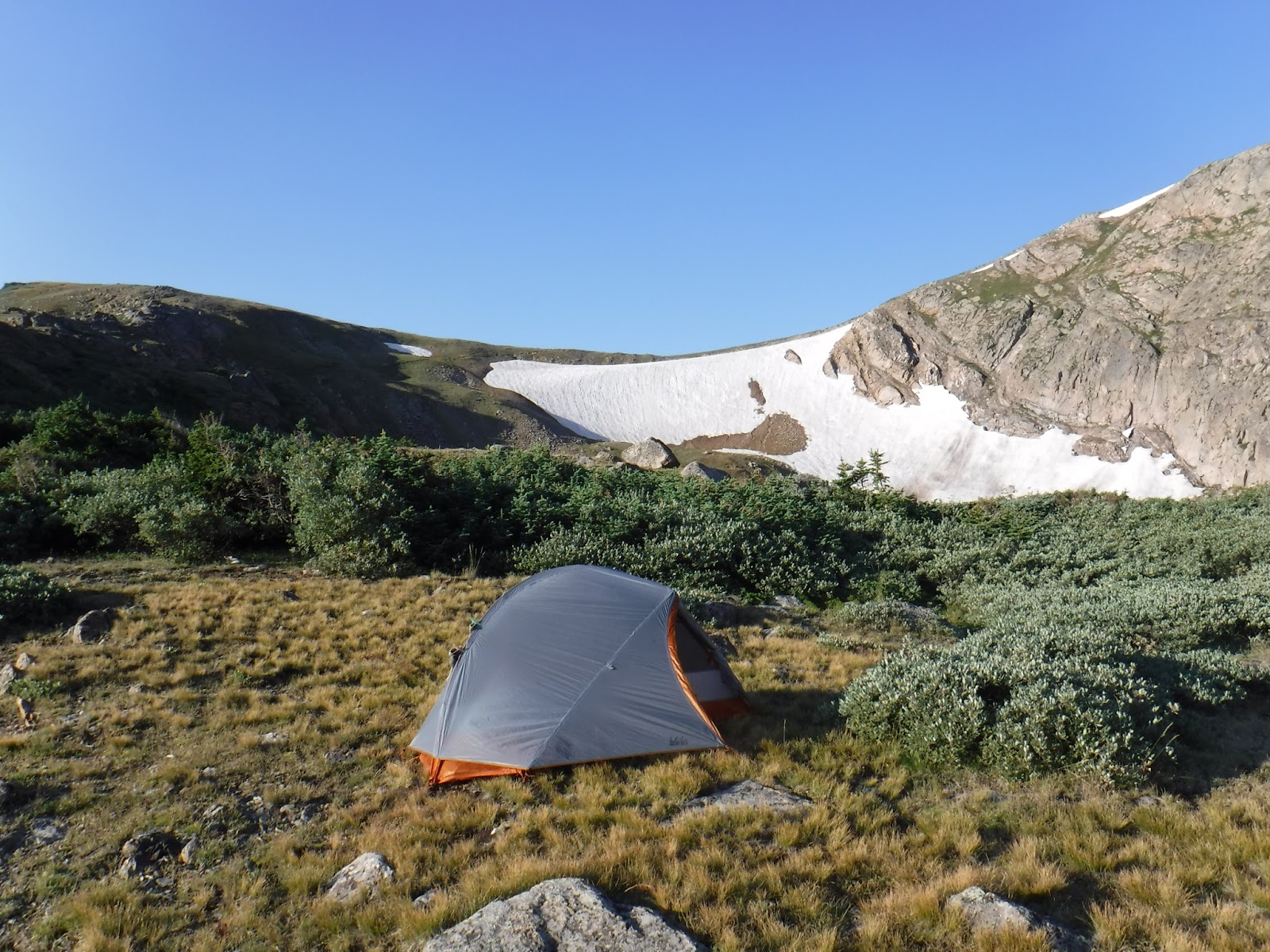
| My REI Quarterdome 1 |
 |
| David's REI dome tent to the south, he is still asleep |
 |
| More sunrise southeast |
Morning light revealed all the miniature world under our feet. Walking on durable surfaces is a good plan, and the paths here are well worn, but even the grasses here have beautiful blooms and tiny petals. This is all tundra, and even the tiniest of plants deserve a full life. Be careful where you step!
 |
| Tundra everywhere underfoot |
 |
| Krumholtz with huge trunks, much bigger around than my leg |
 |
| More tundra by the cooking area |
 |
| And by the lake outflow where we filtered water |
 |
| Beside my tent |
 |
| By where I sat |
The backpack trip had taken us an hour longer to get in than I planned, mostly due to me being a slow, careful walker who takes lots of photos, and all the rocks in the trail to negotiate. (Yes, I know it is the ROCKY Mountains!) With David's help, I crossed that last stream with dry feet this morning, and during the areas with the trail clear of rocks, made good time on the way back. We planned our rest stops and drank plenty of water, making it back downhill to the car an hour and a few minutes quicker than we went up, and that's with a side trip to Lost Lake. We still swatted mosquito's, but realized they didn't bite us.
 |
| Last views of King Lake and the trail up to the CDT |
 |
| Reflections of snow in August |
 |
| Columbine bunch on the downhill march |
As I neared the bridge crossing at Hessie, I was stopped by a few incoming young hikers with questions about my small backpack and gear. "What brand backpack is that?" A Gossamer Gear Kumo. "How much does it weigh?" Empty, 1 pound... "Cool." ...loaded with 2 liters of water, food, fuel and gear, 20 pounds. "What is the most weight it can carry?" 25 pounds. "Could you turn around so I can get a look at it?" And on and on. It felt nice to be recognized as an ultralight backpacker, and I hope they get more curious. 20 pounds used to be a typical day pack for me.
I realize we could have made a loop hike out by climbing to the pass above us, then following the CDT north to Devils Thumb Pass, and following the Devils Thumb Trail back down to Lost Lake, but that would have taken maybe 2-3 more hours than we had initially expected to and would have made a 16-17 mile backpacking trip. You could also hike the Moffat Trail over Rollins Pass and spend much time investigating the other high lakes and campsites in the area plus Lost Lake with all its gold mining sites. As it is, we hiked 12 miles over 2 days, with 2800 feet of elevation gain and had a very pleasant Colorado Rocky Mountain backpacking trip. Get
maps and permit forms HERE.
 |
| Wildflowers and mountains all around |
 |
| The tree in the middle is 5 times larger than I can reach around with both arms |
 |
| David lakeside at our Lost Lake side trip |
 |
| The rough rock road back down |
 |
| Last look back as we near Hessie |
Post trip, we ate a late lunch at the New Moon Bakery in Nederland before braving the return trip through afternoon rush hour traffic back to Castle Rock. David and I discussed the trip, gear, camping and the next backpacking trips I had planned. Once back home, I napped.
Getting there: From Castle Rock it will take at least 90 minutes to drive the mountainous 75 miles, more in rush hour. Go north on US 85 (Santa Fe Trail), then go west on E-470, crossing I-70. Exit 470 to the left to go north on US 6 through Golden. 6 becomes CO 93. Follow CO 93 straight at the intersection north toward Boulder, turning left onto CO 72, Coal Creek Canyon Road. At CO 119 Peak To Peak Highway, turn right, north to Nederland. Turn left onto Eldora Road towards the Ski Area, but stay right at the Ski intersection, continuing on to Eldora. Watch your speed in this small community. When the pavement ends, continue to where the dirt road splits, the Hessie Trailhead is one mile to your left. Portalets were stationed there today. Take care parking along the road, making sure you are between the signs where parking is approved. A typical 2 wheel drive car in good weather is fine to the Hessie turnoff. Or bring your high clearance 4 wheel drive vehicle and continue down the rough dirt road to the left and follow past Hessie to the creek bridge, where there is limited parking.
You can get a campsite permit at the Ace Hardware in Nederland. Instead of turning left to Eldora, just continue straight into town and look for the Ace on the left. The food is good here at the restaurants just past the Ace, across the creek and on the left. The B & F Mountain Market grocery store and an outfitter are on the right just before the creek.
I would plan not to backpack here during the weekends as it is very busy, unless I could be on the trail before 6 am, which means getting the camping permits earlier.